IMAGES TAKEN NEAR TO
Moor Street, CHEPSTOW, NP16 5DF
Introduction
This page details the photographs taken nearby to Moor Street, NP16 5DF by members of the Geograph project.
The Geograph project started in 2005 with the aim of publishing, organising and preserving representative images for every square kilometre of Great Britain, Ireland and the Isle of Man.

There are currently over 7.5m images from over14,400 individuals and you can help contribute to the project by visiting https://www.geograph.org.uk
Image Map
Images are licensed for reuse under creativecommons.org/licenses/by-sa/2.0
Notes
- Clicking on the map will re-center to the selected point.
- The higher the marker number, the further away the image location is from the centre of the postcode.
Image Listing (684 Images Found)
Images are licensed for reuse under creativecommons.org/licenses/by-sa/2.0
Image
Details
Distance
1
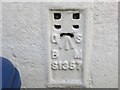
Ordnance Survey Flush Bracket S1357
This can be found on the street-side wall of a building in Moor Street (B4293) in Chepstow.
For more detail see : http://www.bench-marks.org.uk/bm10623
Image: © Peter Wood
Taken: 16 Oct 2016
0.01 miles
2
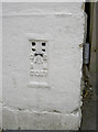
Moor Street flush bracket
The white paint hasn't totally obscured this benchmark. See http://www.bench-marks.org.uk/bm10623 for the entry in the Benchmark Database and Image] for a wider view at the top of the street.
Image: © Neil Owen
Taken: 7 Aug 2013
0.01 miles
3
Moor Street
At the bottom of the corner of this building, under the 5 MPH sign, is a flush bracket. See Image
Image: © Neil Owen
Taken: 7 Aug 2013
0.01 miles
4
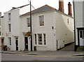
![Chepstow buildings [32]](https://s1.geograph.org.uk/geophotos/07/35/63/7356357_8e5fd204_120x120.jpg)
Chepstow buildings [32]
Numbers 4 to 8 Moor Street were originally a terrace of houses built in the early 19th century. All are now shops with living accommodation above. All are listed, grade II.
Chepstow, the most easterly town in Wales, is located on the tidal River Wye, some 3 miles above its confluence with the River Severn. There is evidence of continuous human occupation from the Mesolithic period. The town grew in importance when the Normans erected a castle at what was the lowest bridging point of the River Wye. The town flourished as a port, being exempt from English taxation, and it mainly traded in timber and bark from the Wye Valley. The town became an important centre for tourism from the late eighteenth century.
Image: © Michael Dibb
Taken: 2 Sep 2022
0.01 miles
5
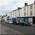
On-street parking, Moor Street, Chepstow
Moor Street is part of the B4293 which extends for 26km from Monmouth to Chepstow.
Image: © Jaggery
Taken: 19 Feb 2018
0.01 miles
6
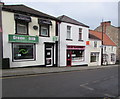
Green Chilli and New Garden, Moor Street, Chepstow
Green Chilli Indian & Bangladeshi takeaway is next door to New Garden Chinese & English takeaway.
Image: © Jaggery
Taken: 19 Feb 2018
0.01 miles
7
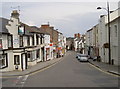
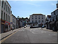
A look down Moor Street
Timing is crucial - even when taking urban scenes - to ensure it looks less busy than it really is.
Image: © Neil Owen
Taken: 7 Aug 2013
0.01 miles
8
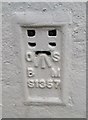
Ordnance Survey Flush Bracket (S1357)
This OS Flush Bracket can be found on the west angle of Olive House. It marks a point 49.735m above mean sea level.
Image: © Adrian Dust
Taken: 27 May 2017
0.01 miles
9
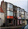
Umut Pizza & Kebab House in Chepstow
Takeaway at 34 Moor Street.
Image: © Jaggery
Taken: 19 Feb 2018
0.01 miles
10
Moor Street, Chepstow, from the Town Gate
Image: © Roy Parkhouse
Taken: 26 May 2002
0.01 miles