IMAGES TAKEN NEAR TO
Regent Way, Mounton Road, CHEPSTOW, NP16 5BY
Introduction
This page details the photographs taken nearby to Regent Way, Mounton Road, NP16 5BY by members of the Geograph project.
The Geograph project started in 2005 with the aim of publishing, organising and preserving representative images for every square kilometre of Great Britain, Ireland and the Isle of Man.

There are currently over 7.5m images from over14,400 individuals and you can help contribute to the project by visiting https://www.geograph.org.uk
Image Map
Images are licensed for reuse under creativecommons.org/licenses/by-sa/2.0
Notes
- Clicking on the map will re-center to the selected point.
- The higher the marker number, the further away the image location is from the centre of the postcode.
Image Listing (529 Images Found)
Images are licensed for reuse under creativecommons.org/licenses/by-sa/2.0
Image
Details
Distance
1
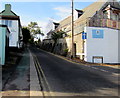
Up Mounton Road, Chepstow
Mounton Road ascends away from Thomas Street past The Old Coach House on the left and the Regent Way junction and Riverside Nursery http://www.geograph.org.uk/photo/5197319 on the right. Double yellow lines on both sides indicate no parking at any time on this one-way road.
Image: © Jaggery
Taken: 11 Nov 2016
0.01 miles
2
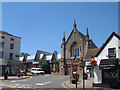
Albion Square, Chepstow
The Methodist Church is the main feature.
Image: © Roy Parkhouse
Taken: 18 Jul 2006
0.02 miles
3
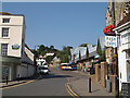
Chepstow Bus Station in Thomas Street
Image: © Roy Parkhouse
Taken: 19 Jul 2006
0.02 miles
4
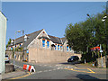
Chepstow - Former Workhouse
At the lower end of Mounton Road.
Image: © Roy Parkhouse
Taken: 19 Jul 2006
0.02 miles
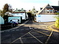
5
![Chepstow houses [28]](https://s0.geograph.org.uk/geophotos/07/35/68/7356884_c4cfa340_120x120.jpg)
Chepstow houses [28]
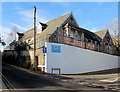
In Mounton Road, Birchfield House, nearer the camera, and Blenheim House were originally built as one property known as Albion House, probably in the late 18th century. It was divided into two houses circa 1860.
Birchfield House occupies the upper bay of the four-bay building, with the main elevation at right angles to the street overlooking the garden to the right. Constructed of stuccoed brick under a tile roof. Listed, grade II, with details at: https://cadwpublic-api.azurewebsites.net/reports/listedbuilding/FullReport?lang=&id=2573
Blenheim house comprises the lower three bays of the four-bay building. Constructed of rendered brick under a machine tile roof. Listed, grade II, with details at: https://cadwpublic-api.azurewebsites.net/reports/listedbuilding/FullReport?lang=&id=2572
Chepstow, the most easterly town in Wales, is located on the tidal River Wye, some 3 miles above its confluence with the River Severn. There is evidence of continuous human occupation from the Mesolithic period. The town grew in importance when the Normans erected a castle at what was the lowest bridging point of the River Wye. The town flourished as a port, being exempt from English taxation, and it mainly traded in timber and bark from the Wye Valley. The town became an important centre for tourism from the late eighteenth century.
Image: © Michael Dibb
Taken: 2 Sep 2022
0.02 miles
6
Riverside Nursery, Chepstow
Children's day nursery located in Regent House on the corner of Regent Way and Mounton Road. Old maps show that the building now known as Regent House was in the southeast corner of the Chepstow Workhouse site. The site was in use from 1838. After 1930, the former workhouse became Regent House Public Assistance Institution. Most of the former workhouse buildings have been demolished.
Image: © Jaggery
Taken: 11 Nov 2016
0.02 miles
7
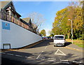
Regent Way, Chepstow
Regent Way ascends from Mounton Road past Riverside Nursery http://www.geograph.org.uk/photo/5197319
on the left towards Chepstow Fire Station. http://www.geograph.org.uk/photo/5189387
Image: © Jaggery
Taken: 11 Nov 2016
0.02 miles
8
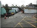
Under repair
Roadworks in Mounton Road, Chepstow.
Image: © Anthony Vosper
Taken: 12 Jan 2023
0.02 miles
9
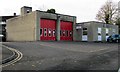
Chepstow Fire Station, Regent Way, Chepstow
Part of the South Wales Fire and Rescue Service, Chepstow Fire Station provides emergency cover for Chepstow and the surrounding area and also responds as the second appliance to calls in the Caldicot area. These areas are in Monmouthshire, Wales. The station also responds to calls in the Sedbury, Tutshill and Tidenham areas of Gloucestershire, England.
Chepstow Fire Station operates two frontline vehicles - a standard water ladder (fire engine) and a pump rescue tender that carries enhanced rescue equipment mostly for use at road traffic collisions. This vehicle also operates as a backup pumping appliance and carries a crew of five firefighters.
Image: © Jaggery
Taken: 11 Nov 2016
0.03 miles
10
Junction at the edge of Chepstow town centre
From the southwest end of Thomas Street looking towards Mounton Road past the right turn into Regent Way.
Image: © Jaggery
Taken: 11 Nov 2016
0.04 miles