IMAGES TAKEN NEAR TO
River View, CHEPSTOW, NP16 5AX
Introduction
This page details the photographs taken nearby to River View, NP16 5AX by members of the Geograph project.
The Geograph project started in 2005 with the aim of publishing, organising and preserving representative images for every square kilometre of Great Britain, Ireland and the Isle of Man.

There are currently over 7.5m images from over14,400 individuals and you can help contribute to the project by visiting https://www.geograph.org.uk
Image Map
Images are licensed for reuse under creativecommons.org/licenses/by-sa/2.0
Notes
- Clicking on the map will re-center to the selected point.
- The higher the marker number, the further away the image location is from the centre of the postcode.
Image Listing (801 Images Found)
Images are licensed for reuse under creativecommons.org/licenses/by-sa/2.0
Image
Details
Distance
1
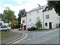
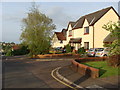
Beaufort Place, Chepstow
Modern houses on the SE side of School Hill.
Image: © Jaggery
Taken: 17 Sep 2010
0.03 miles
2
SW end of School Lane, Chepstow
A view NE from a small gap in the Port Wall. http://www.geograph.org.uk/photo/2066292
Image: © Jaggery
Taken: 13 Nov 2012
0.04 miles
3
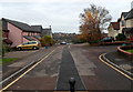
Portwall Road, Chepstow
Portwall Road is a 135-metre long cul-de-sac on the east side of Garden City Way.
Image: © Jaggery
Taken: 13 Nov 2012
0.04 miles
4
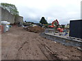
Building site where once there was a bungalow, Chepstow Garden City
The site is beside the town's historic Port Wall.
Image: © Ruth Sharville
Taken: 26 Apr 2019
0.04 miles
5
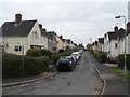
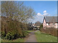
School Hill houses in the evening sunshine
Image: © Ruth Sharville
Taken: 2 May 2009
0.04 miles
6
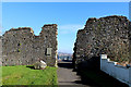
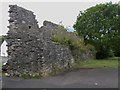
Chepstow - Port Wall at the top of School Hill
An impressive, unbroken, length of Chepstow's Port Wall.
Image: © Roy Parkhouse
Taken: 16 Apr 2008
0.05 miles
7
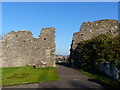
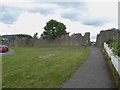
Porth Wall, Chepstow
The town wall that enclosed the medieval borough on the West and South, ran from the castle to the riverbank about three quarters of a mile below the bridge.
It was probably built in the later part of the 13th century and is still intact on a greater part of its length.
This shows the Wales Coast Path heading through a gap in the wall.
Image: © Chris Heaton
Taken: 11 Feb 2016
0.05 miles
8
Portal in the Portwall, Chepstow
This footpath, with its breach of the historic Portwall, leads from Hardwick Estate, otherwise known as Chepstow Garden City, to Tesco supermarket and the railway station.
Image: © Ruth Sharville
Taken: 18 Nov 2018
0.05 miles
9
Portwall, Chepstow
The wall was planned and built by Roger Bigod, 5th Earl of Norfolk during 1272-1278.Two thirds of the wall still survives.
Image: © Eirian Evans
Taken: 22 Jul 2015
0.05 miles
10
Portwall, Chepstow
The wall was planned and built by Roger Bigod, 5th Earl of Norfolk during 1272-1278. Two thirds of the wall still survives.
Image: © Eirian Evans
Taken: 22 Jul 2015
0.05 miles