IMAGES TAKEN NEAR TO
Llanarth, Raglan, USK, NP15 2LZ
Introduction
This page details the photographs taken nearby to NP15 2LZ by members of the Geograph project.
The Geograph project started in 2005 with the aim of publishing, organising and preserving representative images for every square kilometre of Great Britain, Ireland and the Isle of Man.

There are currently over 7.5m images from over14,400 individuals and you can help contribute to the project by visiting https://www.geograph.org.uk
Image Map
Images are licensed for reuse under creativecommons.org/licenses/by-sa/2.0
Notes
- Clicking on the map will re-center to the selected point.
- The higher the marker number, the further away the image location is from the centre of the postcode.
Image Listing (5 Images Found)
Images are licensed for reuse under creativecommons.org/licenses/by-sa/2.0
Image
Details
Distance
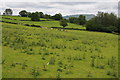
1
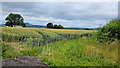
Wheat field opposite Cefn Cottage
Distant view to Ysgyryd Fawr.
Image: © Jonathan Billinger
Taken: 5 Jul 2022
0.00 miles
2
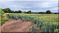
Wheat field opposite Cefn Cottage
Looking north-east.
Image: © Jonathan Billinger
Taken: 5 Jul 2022
0.01 miles
3
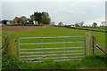
Cefn-coch
The farm buildings are on a slight rise, surrounded by the farm's pastures.
Image: © Graham Horn
Taken: 13 Apr 2012
0.20 miles
4
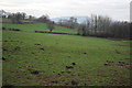
Farmland near Cefn-coch
The profile of Ysgyryd Fawr or Skirrid can be seen in the distance.
Image: © Philip Halling
Taken: 14 Jan 2012
0.21 miles
5
Farmland near Cefn Coch Farm
Same view as last January Image]
Image: © Philip Halling
Taken: 9 Jun 2012
0.22 miles