IMAGES TAKEN NEAR TO
Penrhos, Raglan, USK, NP15 2LQ
Introduction
This page details the photographs taken nearby to NP15 2LQ by members of the Geograph project.
The Geograph project started in 2005 with the aim of publishing, organising and preserving representative images for every square kilometre of Great Britain, Ireland and the Isle of Man.

There are currently over 7.5m images from over14,400 individuals and you can help contribute to the project by visiting https://www.geograph.org.uk
Image Map
Images are licensed for reuse under creativecommons.org/licenses/by-sa/2.0
Notes
- Clicking on the map will re-center to the selected point.
- The higher the marker number, the further away the image location is from the centre of the postcode.
Image Listing (13 Images Found)
Images are licensed for reuse under creativecommons.org/licenses/by-sa/2.0
Image
Details
Distance
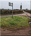
1
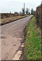
Minor road towards Onen, Monmouthshire
A nearby direction sign https://www.geograph.org.uk/photo/7081918 is 1½ miles from Onen.
Image: © Jaggery
Taken: 23 Jan 2022
0.08 miles
2
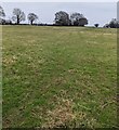
Distant trees in a field in rural Monmouthshire
Viewed from this https://www.geograph.org.uk/photo/7081933 gate in January 2022.
Image: © Jaggery
Taken: 23 Jan 2022
0.08 miles
3
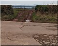
Muddy entrance to a field in rural Monmouthshire
On the north side of this https://www.geograph.org.uk/photo/7081915 grass triangle viewed in January 2022.
Image: © Jaggery
Taken: 23 Jan 2022
0.13 miles
4
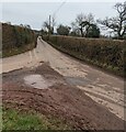
Hedge-lined road towards Penrhos, Monmouthshire
A nearby direction sign https://www.geograph.org.uk/photo/7081915 is 1½ miles from Penrhos.
Image: © Jaggery
Taken: 23 Jan 2022
0.13 miles
5
Direction and distances sign on a grass triangle in rural Monmouthshire
1½ miles from Penrhos, 4½ miles from Dingestow (Llanddingod in Welsh).
Image: © Jaggery
Taken: 23 Jan 2022
0.14 miles
6
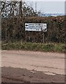
Direction signs at a midway point in rural Monmouthshire
Left for Llantillio Crossenny (Llandello Gresynni in Welsh) (1½ miles). Right for Onen (1½ miles).
Image: © Jaggery
Taken: 23 Jan 2022
0.14 miles
7
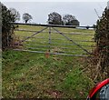
7-bar field gate in rural Monmouthshire
Opposite this https://www.geograph.org.uk/photo/7081915 grass triangle 1½ miles from Penrhos, 4½ miles from Dingestow.
Image: © Jaggery
Taken: 23 Jan 2022
0.14 miles
8
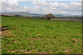
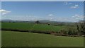
View to the Black Mountains
View to the Black Mountains from Cross Elm to the north of Penrhos. From left to right is Sugar Loaf, Skirrid (Ysgyryd Fawr), the highest point, Waun Fach and to the right Hatterrall Ridge, part of which forms the boundary between England and Wales.
Image: © Philip Halling
Taken: 27 Apr 2013
0.17 miles
9
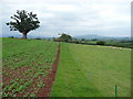
Part of Offa's Dyke Path in Monmouthshire
The old red sandstone influenced soils are very apparent in this area. Distant views to the Skirrid and Sugar Loaf mountains at Abergavenny.
Image: © Jeremy Bolwell
Taken: 6 Sep 2010
0.20 miles
10
Walkers on Offa's Dyke Path, W of The Grange, Llanfihangel Ystum Llewern
Image: © Colin Park
Taken: 18 Apr 2018
0.21 miles