IMAGES TAKEN NEAR TO
Castle Road, USK, NP15 2JZ
Introduction
This page details the photographs taken nearby to Castle Road, NP15 2JZ by members of the Geograph project.
The Geograph project started in 2005 with the aim of publishing, organising and preserving representative images for every square kilometre of Great Britain, Ireland and the Isle of Man.

There are currently over 7.5m images from over14,400 individuals and you can help contribute to the project by visiting https://www.geograph.org.uk
Image Map
Images are licensed for reuse under creativecommons.org/licenses/by-sa/2.0
Notes
- Clicking on the map will re-center to the selected point.
- The higher the marker number, the further away the image location is from the centre of the postcode.
Image Listing (133 Images Found)
Images are licensed for reuse under creativecommons.org/licenses/by-sa/2.0
Image
Details
Distance
1
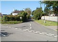
Castle Road, Raglan
Viewed across Monmouth Road. The speed limit for about 300 metres since the Raglan boundary http://www.geograph.org.uk/photo/2086619 has been 40mph, but now it's 30mph as you head towards central Raglan.
Image: © Jaggery
Taken: 26 Sep 2010
0.02 miles
2
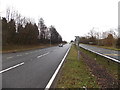
East along the A40, Raglan
The A40 here is a bypass through the northern edge of Raglan.
Image: © Jaggery
Taken: 2 Feb 2014
0.03 miles
3
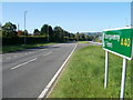
Abergavenny thataway, A40, Raglan
The view from the central reservation along the westbound carriageway of the A40, at the junction http://www.geograph.org.uk/photo/2086553 with Monmouth Road, at the NE edge of Raglan.
Image: © Jaggery
Taken: 26 Sep 2010
0.04 miles
4
Monmouth Road bus stop, Raglan
This is the last (or first) bus stop at the NE edge of Raglan, on the Monmouth route.
Image: © Jaggery
Taken: 26 Sep 2010
0.07 miles
5
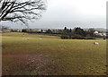
Winter grazing in Raglan
Sheep graze in a rather muddy field. Viewed from Castle Road in early February 2014.
Image: © Jaggery
Taken: 2 Feb 2014
0.13 miles
6
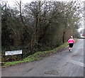
Jogging along Old Monmouth Road, Raglan
Old Monmouth Road here runs parallel with the A40, just out of shot on the right.
Image: © Jaggery
Taken: 5 Jan 2014
0.13 miles
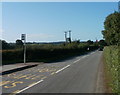
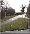
8
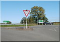
Give Way, A40, Raglan
At the NE edge of Raglan, Monmouth Road reaches the A40. Turn left for Abergavenny, right for Monmouth, Newport (via the A449), or Mitchel Troy via Groesonen Road.
Image: © Jaggery
Taken: 26 Sep 2010
0.14 miles
9
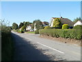
Monmouth Road houses, Raglan
Houses on the north side of the road, east of the Castle Road junction. There are no houses on the south side of the road here - it is all fields, with hedged borders.
Image: © Jaggery
Taken: 26 Sep 2010
0.14 miles
10
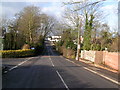
Castle Road, Raglan
From the centre of Raglan, the shortest route to Raglan Castle for walkers is along Castle Street,
Castle Hill, across the A40, and finally Castle Road seen here. The castle is about 400 metres ahead.
Image: © Jaggery
Taken: 2 Feb 2014
0.16 miles