IMAGES TAKEN NEAR TO
Clytha Hill, Raglan, USK, NP15 2JJ
Introduction
This page details the photographs taken nearby to NP15 2JJ by members of the Geograph project.
The Geograph project started in 2005 with the aim of publishing, organising and preserving representative images for every square kilometre of Great Britain, Ireland and the Isle of Man.

There are currently over 7.5m images from over14,400 individuals and you can help contribute to the project by visiting https://www.geograph.org.uk
Image Map
Images are licensed for reuse under creativecommons.org/licenses/by-sa/2.0
Notes
- Clicking on the map will re-center to the selected point.
- The higher the marker number, the further away the image location is from the centre of the postcode.
Image Listing (5 Images Found)
Images are licensed for reuse under creativecommons.org/licenses/by-sa/2.0
Image
Details
Distance
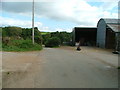
2
Road near Nant-y-carw
Country road immediately to the west of Nant-y-carw, to the north-east of Bettws Newydd.
Image: © Philip Halling
Taken: 11 Nov 2012
0.10 miles
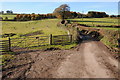
3
Field entrance
Field entrance near Nant-yr-carw.
Image: © Philip Halling
Taken: 11 Nov 2012
0.10 miles
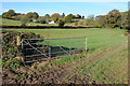
4
Farmland above Pant Brook
Farmland above Pant Brook to the south west of Bryngwyn. I revisited this location during the following autumn Image]
Image: © Philip Halling
Taken: 9 Jun 2012
0.15 miles
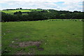
5
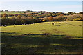
Farmland to the south-west of Bryngwyn
Same view as that last June Image] of farmland above Pant Brook to the south west of Bryngwyn.
Image: © Philip Halling
Taken: 11 Nov 2012
0.17 miles