IMAGES TAKEN NEAR TO
Bryngwyn, Raglan, USK, NP15 2JH
Introduction
This page details the photographs taken nearby to NP15 2JH by members of the Geograph project.
The Geograph project started in 2005 with the aim of publishing, organising and preserving representative images for every square kilometre of Great Britain, Ireland and the Isle of Man.

There are currently over 7.5m images from over14,400 individuals and you can help contribute to the project by visiting https://www.geograph.org.uk
Image Map
Images are licensed for reuse under creativecommons.org/licenses/by-sa/2.0
Notes
- Clicking on the map will re-center to the selected point.
- The higher the marker number, the further away the image location is from the centre of the postcode.
Image Listing (3 Images Found)
Images are licensed for reuse under creativecommons.org/licenses/by-sa/2.0
Image
Details
Distance
1
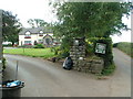
Harvest House B&B with rubbish awaiting collection
This B&B has a lovely mini lake in the back garden and looks like a nice place to stay.
Image: © Nick Mutton 01329 000000
Taken: 11 Sep 2007
0.02 miles
2
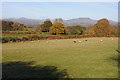
View to the Black Mountains
The main range of the Black Mountains lie beyond the southern outliers pictured here, they include Sugar Loaf on the left, and Skirrid to the right.
Image: © Philip Halling
Taken: 11 Nov 2012
0.22 miles
3
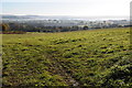
Mist hangs over the Monmouthshire countryside
Mist hangs over the Monmouthshire countryside viewed here from near Bryngwyn.
Image: © Philip Halling
Taken: 11 Nov 2012
0.23 miles