IMAGES TAKEN NEAR TO
Chepstow Road, USK, NP15 2HY
Introduction
This page details the photographs taken nearby to Chepstow Road, NP15 2HY by members of the Geograph project.
The Geograph project started in 2005 with the aim of publishing, organising and preserving representative images for every square kilometre of Great Britain, Ireland and the Isle of Man.

There are currently over 7.5m images from over14,400 individuals and you can help contribute to the project by visiting https://www.geograph.org.uk
Image Map
Images are licensed for reuse under creativecommons.org/licenses/by-sa/2.0
Notes
- Clicking on the map will re-center to the selected point.
- The higher the marker number, the further away the image location is from the centre of the postcode.
Image Listing (6 Images Found)
Images are licensed for reuse under creativecommons.org/licenses/by-sa/2.0
Image
Details
Distance
2
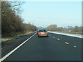
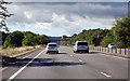
Raglan : A449
Looking along the A449 dual carriageway.
Image: © Lewis Clarke
Taken: 22 Mar 2023
0.17 miles
3
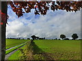
Looking towards Gwern-eiddig Farm, near Raglan
Image: © Ruth Sharville
Taken: 22 Oct 2013
0.19 miles
4
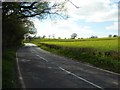
Minor road to the south of Raglan
This unclassified road to the south of Raglan has the appearance of an A or B road. Before the building of the A449 dual carriageway this may well have been an A road.
Image: © Philip Halling
Taken: 6 Apr 2017
0.21 miles
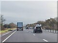
5
A449 heading south
The road runs right down the edge of SO4105.
Image: © Julian P Guffogg
Taken: 9 Aug 2013
0.22 miles
6
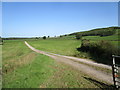
Track to Lower House
Lowerhouse Wood on the right.
Image: © Jonathan Thacker
Taken: 17 Sep 2020
0.24 miles