IMAGES TAKEN NEAR TO
Monmouth Road, USK, NP15 2ET
Introduction
This page details the photographs taken nearby to Monmouth Road, NP15 2ET by members of the Geograph project.
The Geograph project started in 2005 with the aim of publishing, organising and preserving representative images for every square kilometre of Great Britain, Ireland and the Isle of Man.

There are currently over 7.5m images from over14,400 individuals and you can help contribute to the project by visiting https://www.geograph.org.uk
Image Map
Images are licensed for reuse under creativecommons.org/licenses/by-sa/2.0
Notes
- Clicking on the map will re-center to the selected point.
- The higher the marker number, the further away the image location is from the centre of the postcode.
Image Listing (249 Images Found)
Images are licensed for reuse under creativecommons.org/licenses/by-sa/2.0
Image
Details
Distance
1
Barton Bridge Close, Raglan
Viewed from Old Monmouth Road in the north of Raglan.
Image: © Jaggery
Taken: 5 Jan 2014
0.06 miles
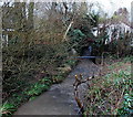
2
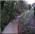
Barton Brook, Raglan
Viewed from Monmouth Road.
Image: © Jaggery
Taken: 2 Feb 2014
0.06 miles
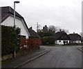
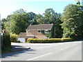
4
Raglan : Monmouth Road approaches Station Road
The left turn ahead is for Station Road. A more appropriate name nowadays would be 'Golf Course Road'. Raglan Parc Golf Club is at the far end of Station Road. Raglan railway station closed in 1955.
Image: © Jaggery
Taken: 26 Sep 2010
0.08 miles
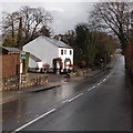
5
Dinglewood, Raglan
House on the corner of Station Road and Monmouth Road.
Image: © Jaggery
Taken: 26 Sep 2010
0.08 miles
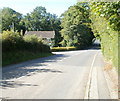
6
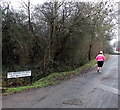
Jogging along Old Monmouth Road, Raglan
Old Monmouth Road here runs parallel with the A40, just out of shot on the right.
Image: © Jaggery
Taken: 5 Jan 2014
0.08 miles
7
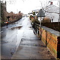
Puddle on Monmouth Road, Raglan
Viewed across the bridge over Barton Brook. http://www.geograph.org.uk/photo/3845227 Walkers such as this contributor needed to be watchful to avoid a soaking from a passing vehicle. Some of the puddle water has already been sprayed onto the pavement by traffic.
Image: © Jaggery
Taken: 2 Feb 2014
0.09 miles
8

Crossing the A40
For pedestrians going from Rgalan village to the Castle it is necessary to cross the dual carriageway A40. There is an island in the middle but especially with a limited view to the east and given the speed with which vehicles travel this a pedestrian nightmare. Shame on whoever planned it.
Image: © Jonathan Thacker
Taken: 17 Sep 2020
0.09 miles
9
Monmouth Road bus stop, Raglan
Used by buses on the Newport to Monmouth and Abergavenny to Monmouth routes.
Image: © Jaggery
Taken: 2 Feb 2014
0.09 miles
10
Pipe over Barton Brook, Raglan
On the south side of Castle Hill.
Image: © Jaggery
Taken: 2 Feb 2014
0.09 miles