IMAGES TAKEN NEAR TO
Tregare, Raglan, USK, NP15 2DL
Introduction
This page details the photographs taken nearby to NP15 2DL by members of the Geograph project.
The Geograph project started in 2005 with the aim of publishing, organising and preserving representative images for every square kilometre of Great Britain, Ireland and the Isle of Man.

There are currently over 7.5m images from over14,400 individuals and you can help contribute to the project by visiting https://www.geograph.org.uk
Image Map
Images are licensed for reuse under creativecommons.org/licenses/by-sa/2.0
Notes
- Clicking on the map will re-center to the selected point.
- The higher the marker number, the further away the image location is from the centre of the postcode.
Image Listing (3 Images Found)
Images are licensed for reuse under creativecommons.org/licenses/by-sa/2.0
Image
Details
Distance
1
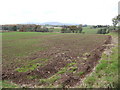
Arable field
View west of the crossroads; in sight is the Skirrid and Sugarloaf hills in the distance.
Image: © Jonathan Billinger
Taken: 8 Nov 2007
0.21 miles
2
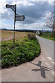
Crossroads near Tregare
Sign on a crossroads to the west of Tregare.
Image: © Philip Halling
Taken: 27 Apr 2013
0.23 miles
3
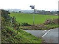
The Raglan turning at the crossroads west of Tregare
Image: © Ruth Sharville
Taken: 19 Oct 2014
0.23 miles