IMAGES TAKEN NEAR TO
Clytha, USK, NP15 2BQ
Introduction
This page details the photographs taken nearby to Clytha, NP15 2BQ by members of the Geograph project.
The Geograph project started in 2005 with the aim of publishing, organising and preserving representative images for every square kilometre of Great Britain, Ireland and the Isle of Man.

There are currently over 7.5m images from over14,400 individuals and you can help contribute to the project by visiting https://www.geograph.org.uk
Image Map
Images are licensed for reuse under creativecommons.org/licenses/by-sa/2.0
Notes
- Clicking on the map will re-center to the selected point.
- The higher the marker number, the further away the image location is from the centre of the postcode.
Image Listing (6 Images Found)
Images are licensed for reuse under creativecommons.org/licenses/by-sa/2.0
Image
Details
Distance
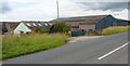
2
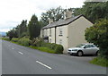
Rose Cottage west of Raglan
Located on the north side of the old Raglan to Abergavenny road about 3km NW of central Raglan.
Image: © Jaggery
Taken: 15 Jul 2012
0.15 miles
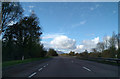
3
Looking west along the A40 from Bryngwyn near Raglan
Viewed from the bridge connecting Bryngwyn with the old Raglan to Abergavenny Road.
Abergavenny is about 12km ahead. The centre of Raglan is about 3km behind the camera.
Image: © Jaggery
Taken: 15 Jul 2012
0.18 miles
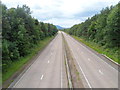
4
West along Old Abergavenny Road
Viewed from the access road to Monmouthshire Livestock Centre.
Ahead for Abergavenny. Behind the camera for Raglan.
Image: © Jaggery
Taken: 2 Jan 2022
0.22 miles
5
West side of High House Farm, Bryngwyn near Raglan
Viewed from the old Abergavenny to Raglan road.
Image: © Jaggery
Taken: 15 Jul 2012
0.23 miles
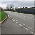
6
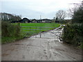
Muddy track to Nant-chwith
South of the old A40, west of Raglan Garden Centre.
Image: © Jonathan Billinger
Taken: 14 Dec 2009
0.23 miles