IMAGES TAKEN NEAR TO
Bryngwyn, Raglan, USK, NP15 2AE
Introduction
This page details the photographs taken nearby to NP15 2AE by members of the Geograph project.
The Geograph project started in 2005 with the aim of publishing, organising and preserving representative images for every square kilometre of Great Britain, Ireland and the Isle of Man.

There are currently over 7.5m images from over14,400 individuals and you can help contribute to the project by visiting https://www.geograph.org.uk
Image Map (Loading...)


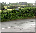
Getting Data...Please wait
Leaflet Map data © OpenStreetMap
Images are licensed for reuse under creativecommons.org/licenses/by-sa/2.0
Notes
- Clicking on the map will re-center to the selected point.
- The higher the marker number, the further away the image location is from the centre of the postcode.
Image Listing (69 Images Found)
Images are licensed for reuse under creativecommons.org/licenses/by-sa/2.0
Image
Details
Distance
1
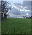
Grass field in Byngwyn, Monmouthshire
Looking south from near the stile at the SW edge of St Peter's churchyard.
Image: © Jaggery
Taken: 2 Jan 2022
0.06 miles
2

Bus stop on the road to Great Oak
The bus stop is on bus route 83 from Monmouth to Abergavenny via Raglan.
Image: © Jaggery
Taken: 15 Jul 2012
0.08 miles
3
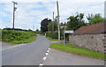
Ahead for Bryngwyn or left for Great Oak
The junction is a few metres north of the bridge carrying the road over the A40 about 3km from Raglan.
Image: © Jaggery
Taken: 15 Jul 2012
0.08 miles
5

Telecoms mast behind trees, Bryngwyn, Monmouthshire
Near the edge of St Peter's churchyard.
Image: © Jaggery
Taken: 2 Jan 2022
0.12 miles
6
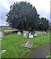
Churchyard yews, Bryngwyn, Monmouthshire
In St Peter's churchyard viewed on January 2nd 2022. The European Yew (Taxus baccata) is an evergreen tree often found in churchyards in the UK, Ireland, France and northern parts of Spain.
Image: © Jaggery
Taken: 2 Jan 2022
0.12 miles
7
Distances from Bryngwyn, Monmouthshire
The signs in a hedge face this grass triangle and tree. http://www.geograph.org.uk/photo/4575503
Left for Tregare (2½ miles), right for Raglan (2 miles).
Image: © Jaggery
Taken: 19 Jul 2015
0.13 miles
8
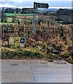
Grimy direction and distance signs, Bryngwyn
Grimy in January 2022. Left for Tregare (2½ (miles)), right for Raglan (2).
Image: © Jaggery
Taken: 2 Jan 2022
0.13 miles
9
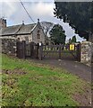
Main entrance to the churchyard, Bryngwyn
Ahead for St Peter's churchyard and church in the Church in Wales Diocese of Monmouth.
Image: © Jaggery
Taken: 2 Jan 2022
0.13 miles
10
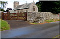
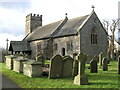
Entrance to St Peter's Church, Bryngwyn, Monmouthshire
The church http://www.geograph.org.uk/photo/4575486 is part of the Church in Wales Diocese of Monmouth. The stepped mounting block
against the wall is a relic of the time when some parishioners and perhaps the minister arrived on horseback.
The red postbox http://www.geograph.org.uk/photo/4575492 in the wall is from the reign of King George V.
Image: © Jaggery
Taken: 19 Jul 2015
0.13 miles