IMAGES TAKEN NEAR TO
Cassia Drive, USK, NP15 1TZ
Introduction
This page details the photographs taken nearby to Cassia Drive, NP15 1TZ by members of the Geograph project.
The Geograph project started in 2005 with the aim of publishing, organising and preserving representative images for every square kilometre of Great Britain, Ireland and the Isle of Man.

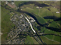
There are currently over 7.5m images from over14,400 individuals and you can help contribute to the project by visiting https://www.geograph.org.uk
Image Map
Images are licensed for reuse under creativecommons.org/licenses/by-sa/2.0
Notes
- Clicking on the map will re-center to the selected point.
- The higher the marker number, the further away the image location is from the centre of the postcode.
Image Listing (48 Images Found)
Images are licensed for reuse under creativecommons.org/licenses/by-sa/2.0
Image
Details
Distance
1
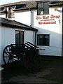
Rat Trap Inn near Usk
The Rat Trap is the contraption in the foreground!
Image: © Roy Haworth
Taken: 18 Oct 2007
0.05 miles
2
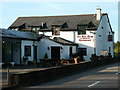
Rat Trap Inn near Usk
Situated on the old Chepstow Road, this inn has been refurbished since we went and attracts visitors by the reputation of its restaurant.
Image: © Roy Haworth
Taken: 18 Oct 2007
0.06 miles
3
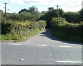
Entrance lane to Little Castle Farm, Usk
Viewed across Monmouth Road from the corner of Factory Lane. http://www.geograph.org.uk/photo/2093549
Image: © Jaggery
Taken: 26 Sep 2010
0.07 miles
4
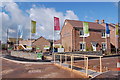
Burrium Gate, Usk
Viewed from Monmouth Road. Burrium Gate is a 2008 Barratt development of 28 4- and 5-bedroom detached houses, at the NE edge of Usk.
Image: © Jaggery
Taken: 26 Sep 2010
0.09 miles
5
Burrium Chase housing development in Usk
View looks westwards towards the small market town of Usk. This is part of a new housing development by Barratt homes called Burrium Chase (seen here) and Burrium Gate (to the immediate south) respectively. Burrium was the name given by the Romans to their fort in what is now Usk.
Image: © Roger Davies
Taken: 13 Apr 2008
0.09 miles
6
Entrance gate to Usk allotments
Located on the west side of the allotments, a few metres along Factory Lane http://www.geograph.org.uk/photo/2093549 from its junction with Monmouth Road.
Image: © Jaggery
Taken: 26 Sep 2010
0.11 miles
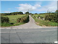
7
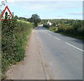
Monmouth Road leaves Usk
Just beyond Burrium Gate, http://www.geograph.org.uk/photo/2094050 Monmouth Road heads away NE from the Usk boundary.
Image: © Jaggery
Taken: 26 Sep 2010
0.11 miles
8
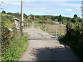
Factory Lane, Usk
With a name that contradicts its rural setting, Factory Lane heads away from the south side of Monmouth Road. At a gap in the hedge on the left side of the lane is the entrance gate http://www.geograph.org.uk/photo/2093539 to allotments.
Image: © Jaggery
Taken: 26 Sep 2010
0.11 miles
10
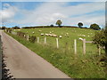
Grazing sheep, Little Castle Farm, Usk
Viewed from the corner of Monmouth Road, looking across the eastern edge of the farm access lane. http://www.geograph.org.uk/photo/2093553
Image: © Jaggery
Taken: 26 Sep 2010
0.13 miles