IMAGES TAKEN NEAR TO
Usk Bridge Mews, Bridge Street, USK, NP15 1SW
Introduction
This page details the photographs taken nearby to Usk Bridge Mews, Bridge Street, NP15 1SW by members of the Geograph project.
The Geograph project started in 2005 with the aim of publishing, organising and preserving representative images for every square kilometre of Great Britain, Ireland and the Isle of Man.

There are currently over 7.5m images from over14,400 individuals and you can help contribute to the project by visiting https://www.geograph.org.uk
Image Map
Images are licensed for reuse under creativecommons.org/licenses/by-sa/2.0
Notes
- Clicking on the map will re-center to the selected point.
- The higher the marker number, the further away the image location is from the centre of the postcode.
Image Listing (804 Images Found)
Images are licensed for reuse under creativecommons.org/licenses/by-sa/2.0
Image
Details
Distance
1
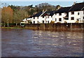
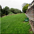
Swollen River Usk viewed from Usk Bridge, Usk
During a wet period at the end of January 2013, the increased volume of water in the River Usk has flooded many nearby river meadows. Here, the river has submerged a footpath http://www.geograph.org.uk/photo/3352921 on the east bank. Railings on the right descend into water.
Image: © Jaggery
Taken: 27 Jan 2013
0.01 miles
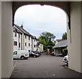
2
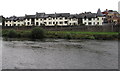
Usk Bridge Mews, Usk
Housing on the east bank of the River Usk, viewed from a path on the west bank.
The narrow vertical white strip on the wall on the right is a flood gauge.
Image: © Jaggery
Taken: 30 Aug 2015
0.01 miles
3
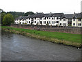
Riverside properties, east bank
Viewed from Usk Bridge.
Image: © Pauline E
Taken: 2 Aug 2009
0.01 miles
4
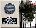
Mediaeval hospital blue plaque, Usk
The plaque at the edge of Bridge Street near Usk Bridge marks the site of the town's mediaeval hospital,
now Usk Bridge Mews. http://www.geograph.org.uk/photo/4639717
Image: © Jaggery
Taken: 30 Aug 2015
0.01 miles
5
Riverbank bench, Usk
On the east bank of the River Usk in the Monmouthshire town of Usk, north of Usk Bridge.
Image: © Jaggery
Taken: 30 Aug 2015
0.01 miles
6
Usk Bridge Mews, Usk
Modern housing on the east bank of the River Usk, viewed from Bridge Street.
A nearby blue plaque http://www.geograph.org.uk/photo/4639738 records that this was the site of Usk's mediaeval hospital until 1402.
Image: © Jaggery
Taken: 30 Aug 2015
0.01 miles
7
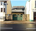
Former House of Correction, Usk
The building set back from the north side of Bridge Street was formerly the House of Correction or Old Bridewell, in use for about 200 years from 1642. It was the forerunner of Usk Prison, and had two predecessors. The earliest was the garrison in Usk Castle, followed by the building further along Bridge Street now named Gordon House.
Image: © Jaggery
Taken: 27 Jan 2013
0.01 miles
8
SW end of Bridge Street
Looking across the A472 from the eastern end of Usk Bridge. The left turn is into Usk Bridge Mews. http://www.geograph.org.uk/photo/4639717
Image: © Jaggery
Taken: 30 Aug 2015
0.01 miles
9
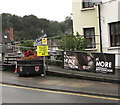
Fire Brigade recruiting banner, Bridge Street, Usk
On display in August 2020. Text in view includes BE MORE and RECRUITING NOW.
The banner text is also in Welsh.
Image: © Jaggery
Taken: 16 Aug 2020
0.01 miles
10
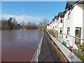
Flooded riverside footpath, Usk
For most of the time, this footpath on the east bank of the River Usk gives a route northwards, but not today. The River Usk has flooded nearby fields, and here has caused minor flooding. A few walkers explored the depth of the flood but all wisely decided to turn back and use another route.
The houses are in Usk Bridge Mews.
Image: © Jaggery
Taken: 27 Jan 2013
0.02 miles