IMAGES TAKEN NEAR TO
Ladyhill Close, USK, NP15 1SJ
Introduction
This page details the photographs taken nearby to Ladyhill Close, NP15 1SJ by members of the Geograph project.
The Geograph project started in 2005 with the aim of publishing, organising and preserving representative images for every square kilometre of Great Britain, Ireland and the Isle of Man.

There are currently over 7.5m images from over14,400 individuals and you can help contribute to the project by visiting https://www.geograph.org.uk
Image Map
Images are licensed for reuse under creativecommons.org/licenses/by-sa/2.0
Notes
- Clicking on the map will re-center to the selected point.
- The higher the marker number, the further away the image location is from the centre of the postcode.
Image Listing (236 Images Found)
Images are licensed for reuse under creativecommons.org/licenses/by-sa/2.0
Image
Details
Distance
1

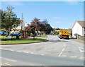
Cycle Route 423 sign, Monmouth Road, Usk
National Cycle Network Route 423 follows the former Regional
Route 30 and the Peregrine Path from Cwmbran to Ross-on-Wye via Monmouth.
Image: © Jaggery
Taken: 3 Nov 2018
0.08 miles
2
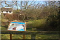
Castle Oak pond, Usk
This pond was originally excavated in the 1850s to provide water for the steam trains on the line between Little Mill and Monmouth. During the excavation skeletons were found believed to be those slain at the battle of Pwll Melyn in 1405 when Owen Glendower's forces were heavily defeated by those of Henry IV. The line was closed in 1955 by Lord Beeching. Despite now being totally surrounded by the Castle Oak housing estate the pond is home to a rare amphibian -the greater crested newt.
Image: © Roger Davies
Taken: 30 Mar 2008
0.08 miles
3
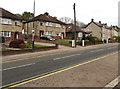
Monmouth Road houses, Usk
Houses on the north side of the A472 Monmouth Road.
Image: © Jaggery
Taken: 3 Nov 2018
0.08 miles
4
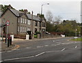
Monmouth Road from A road to unclassified road, Usk
The A472 Monmouth Road on the camera side becomes the unclassified Monmouth Road on the left side of the junction. The A472 continues as an unnamed road on the right side of the junction.
Image: © Jaggery
Taken: 3 Nov 2018
0.08 miles
5
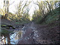
Path east from the former Usk railway tunnel
Following the route of the dismantled railway line east of Usk tunnel http://www.geograph.org.uk/photo/3312189 and the demolished Usk railway station on the far side of the tunnel, a path heads towards the Monmouth road.
Image: © Jaggery
Taken: 27 Jan 2013
0.09 miles
6

Path junction on the north side of Monmouth Road, Usk
The path ahead leads to houses in Sunnyside.
Image: © Jaggery
Taken: 3 Nov 2018
0.09 miles
7
Corner of Ladyhill and Monmouth Road, Usk
Viewed from Monmouth Road.
Image: © Jaggery
Taken: 26 Sep 2010
0.09 miles
8
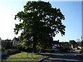
Castle Oak at Castle Oak
Mighty tree gives its name to the street.
Image: © Ian Paterson
Taken: 1 May 2007
0.09 miles
9
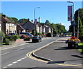
Monmouth Road, Usk
Looking to the NE along the A472 Monmouth Road from the corner of Castle Mews.
An Usk in Bloom flower tub is on the right.
Image: © Jaggery
Taken: 30 Aug 2020
0.09 miles
10
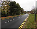
West along the A472, Usk
This part of the A472, at the eastern edge of Usk, is unnamed.
A little out of shot ahead, it becomes the A472 Monmouth Road.
Double yellow lines on both sides of the road indicate no parking at any time.
Image: © Jaggery
Taken: 3 Nov 2018
0.09 miles