IMAGES TAKEN NEAR TO
Monmouth Road, USK, NP15 1SF
Introduction
This page details the photographs taken nearby to Monmouth Road, NP15 1SF by members of the Geograph project.
The Geograph project started in 2005 with the aim of publishing, organising and preserving representative images for every square kilometre of Great Britain, Ireland and the Isle of Man.

There are currently over 7.5m images from over14,400 individuals and you can help contribute to the project by visiting https://www.geograph.org.uk
Image Map
Images are licensed for reuse under creativecommons.org/licenses/by-sa/2.0
Notes
- Clicking on the map will re-center to the selected point.
- The higher the marker number, the further away the image location is from the centre of the postcode.
Image Listing (108 Images Found)
Images are licensed for reuse under creativecommons.org/licenses/by-sa/2.0
Image
Details
Distance
1
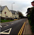
One-way part of Monmouth Road, Usk
This part of Monmouth Road is between Ladyhill and the A472 out of shot ahead.
Image: © Jaggery
Taken: 3 Nov 2018
0.02 miles
2
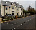
Railway House, Monmouth Road, Usk
On the left here. https://www.geograph.org.uk/photo/5962779 Old maps show railway lines nearby,
near Usk railway station where passenger services ended in 1955.
Image: © Jaggery
Taken: 3 Nov 2018
0.02 miles
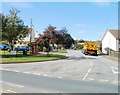
3

Monmouth Road bus stop and shelter, Usk
This stop is for buses to Monmouth via Raglan, Dingestow and Mitchel Troy.
SAFLE BWS is Welsh for BUS STOP.
Image: © Jaggery
Taken: 3 Nov 2018
0.04 miles
4

Path junction on the north side of Monmouth Road, Usk
The path ahead leads to houses in Sunnyside.
Image: © Jaggery
Taken: 3 Nov 2018
0.04 miles
5
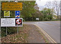
Lorry watch notice at the eastern edge of Usk
There is a 7.5 tonnes vehicle weight limit through Usk town, except for loading.
A lorry watch operates in this area - offenders will be reported. Maximum fine in November 2018 is £1,000.
Image: © Jaggery
Taken: 3 Nov 2018
0.04 miles
6
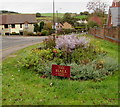
Flowerbed alongside Monmouth Road, Usk
Sponsored by the Hall Inn at Gwehelog, the floral display is long past its prime on November 3rd 2018.
Image: © Jaggery
Taken: 3 Nov 2018
0.04 miles
7
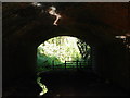
Bridge at Bullfinch Walk
The Bright sunlight outside is reflected via the stream onto the roof of the old railway bridge.
Image: © Ian Paterson
Taken: 1 May 2007
0.04 miles
8
Corner of Ladyhill and Monmouth Road, Usk
Viewed from Monmouth Road.
Image: © Jaggery
Taken: 26 Sep 2010
0.04 miles
9

Usk - Town of Flowers/Tref o Flodau
The English/Welsh boundary sign is on the north side of the A472 at the eastern edge of Usk, Monmouthshire.
Image: © Jaggery
Taken: 3 Nov 2018
0.04 miles
10
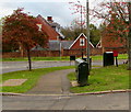
Two telecoms cabinets and a postbox on an Usk corner
On the corner of Ladyhill and Monmouth Road viewed in November 2018.
The red phonebox formerly on this corner, seen here http://www.geograph.org.uk/photo/2094087 in 2010, has been removed.
Image: © Jaggery
Taken: 3 Nov 2018
0.04 miles