IMAGES TAKEN NEAR TO
Cold Harbour, USK, NP15 1RS
Introduction
This page details the photographs taken nearby to NP15 1RS by members of the Geograph project.
The Geograph project started in 2005 with the aim of publishing, organising and preserving representative images for every square kilometre of Great Britain, Ireland and the Isle of Man.

There are currently over 7.5m images from over14,400 individuals and you can help contribute to the project by visiting https://www.geograph.org.uk
Image Map
Images are licensed for reuse under creativecommons.org/licenses/by-sa/2.0
Notes
- Clicking on the map will re-center to the selected point.
- The higher the marker number, the further away the image location is from the centre of the postcode.
Image Listing (13 Images Found)
Images are licensed for reuse under creativecommons.org/licenses/by-sa/2.0
Image
Details
Distance
1
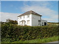
Woodland View, Usk Road
Located on the west side of Usk Road, a house with its own bus stop. http://www.geograph.org.uk/photo/2090817
Image: © Jaggery
Taken: 26 Sep 2010
0.03 miles
2
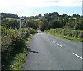
Woodland View bus stop, Usk Road
The view south along Usk Road as it passes a bus stop named Woodland View. The house with that name http://www.geograph.org.uk/photo/2090808 is directly opposite.
Image: © Jaggery
Taken: 26 Sep 2010
0.03 miles
3
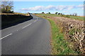
Road to the north of Gwehelog
Road between Usk and Raglan to the north of Gwehelog.
Image: © Philip Halling
Taken: 11 Nov 2012
0.04 miles
4
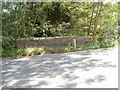
Wecha Brook Bridge, Usk Road
Usk Road passes above Wecha Brook along a bridge with a conspicuous crack in the stonework. The milestone http://www.geograph.org.uk/photo/2090847 shows Usk 3 miles Monmouth 10 miles.
Image: © Jaggery
Taken: 26 Sep 2010
0.08 miles
5
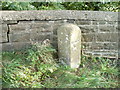
Milestone on Wecha Brook Bridge, Usk Road
Next to a crack in the stonework on Wecha Brook Bridge, http://www.geograph.org.uk/photo/2090835 an old milestone shows Usk 3 miles Monmouth 10 miles.
Image: © Jaggery
Taken: 26 Sep 2010
0.08 miles
6
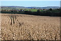
A maize crop
A maize crop beside the Usk to Raglan road to the north of Gwehelog.
Image: © Philip Halling
Taken: 11 Nov 2012
0.10 miles
7
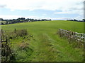
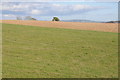
Field on the west side of Usk Road
The view SW across a field accessed from the west side of Usk Road. http://www.geograph.org.uk/photo/2090735
Image: © Jaggery
Taken: 26 Sep 2010
0.14 miles
8
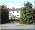
Yewtree Cottage, Usk Road
Set back from the west side of Usk Road, to the north of Gwehelog
Image: © Jaggery
Taken: 26 Sep 2010
0.17 miles
9
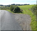
Field entrance, Usk Road
About 200 metres south of Ton Cottages, http://www.geograph.org.uk/photo/2090709 a gap in the hedges leads into a field http://www.geograph.org.uk/photo/2090743 on the west side of Usk Road.
Image: © Jaggery
Taken: 26 Sep 2010
0.17 miles
10
Farmland near Gwehelog
Grazing land and a field of maize to the north of Gwehelog.
Image: © Philip Halling
Taken: 11 Nov 2012
0.18 miles