IMAGES TAKEN NEAR TO
Gwehelog, USK, NP15 1RJ
Introduction
This page details the photographs taken nearby to NP15 1RJ by members of the Geograph project.
The Geograph project started in 2005 with the aim of publishing, organising and preserving representative images for every square kilometre of Great Britain, Ireland and the Isle of Man.

There are currently over 7.5m images from over14,400 individuals and you can help contribute to the project by visiting https://www.geograph.org.uk
Image Map
Images are licensed for reuse under creativecommons.org/licenses/by-sa/2.0
Notes
- Clicking on the map will re-center to the selected point.
- The higher the marker number, the further away the image location is from the centre of the postcode.
Image Listing (18 Images Found)
Images are licensed for reuse under creativecommons.org/licenses/by-sa/2.0
Image
Details
Distance
2
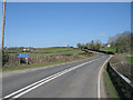
Southern approach to Gwehelog
Southern edge of the village on the old Usk to Raglan road.
Image: © M J Roscoe
Taken: 1 Mar 2019
0.07 miles
3
Gwehelog, Monmouthshire
Looking north on the road from Usk to Gwehelog, Monmouthshire
Image: © Peter Wasp
Taken: 17 Mar 2007
0.07 miles
4
Sheep, Great House Farm, Gwehelog
Viewed from Usk Road. Sheep graze in a field on the north side of the entrance road to Great House Farm. http://www.geograph.org.uk/photo/2092726
Image: © Jaggery
Taken: 26 Sep 2010
0.07 miles
5
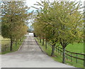
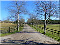
Tree-lined entrance to Great House Farm, Gwehelog
Viewed from Usk Road.
Image: © Jaggery
Taken: 26 Sep 2010
0.07 miles
6
Great House Farm, Gwehelog
Farm buildings viewed from Usk Road.
Image: © Jaggery
Taken: 26 Sep 2010
0.07 miles
7
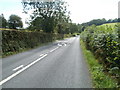
White arrows, Usk Road, Gwehelog
Heading south out of Gwehelog, Usk Road approaches a bend, before which double arrows indicate a change in road marking. On the camera side, the broken white line indicates that traffic on the left can cross the middle of the highway, whereas beyond the arrows, the broken line is on the other side.
Image: © Jaggery
Taken: 26 Sep 2010
0.10 miles
8
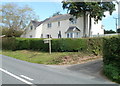
The Rock, Gwehelog
House on the eastern side of Usk Road, in southern Gwehelog.
Image: © Jaggery
Taken: 26 Sep 2010
0.10 miles
9
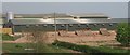
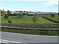
Chicken farm
The buildings for this chicken farm are not shown on the map - probably too new.
Image: © Ruth Sharville
Taken: 20 Apr 2007
0.10 miles
10
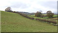
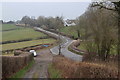
Countryside at Gwehelog
Looking north-west from the Usk to Raglan road.
Land use hereabouts is predominantly pasture and woodland.
Image: © Jonathan Billinger
Taken: 21 Nov 2007
0.12 miles