IMAGES TAKEN NEAR TO
Wainfield Lane, USK, NP15 1RG
Introduction
This page details the photographs taken nearby to Wainfield Lane, NP15 1RG by members of the Geograph project.
The Geograph project started in 2005 with the aim of publishing, organising and preserving representative images for every square kilometre of Great Britain, Ireland and the Isle of Man.

There are currently over 7.5m images from over14,400 individuals and you can help contribute to the project by visiting https://www.geograph.org.uk
Image Map (Loading...)


Getting Data...Please wait
Leaflet Map data © OpenStreetMap
Images are licensed for reuse under creativecommons.org/licenses/by-sa/2.0
Notes
- Clicking on the map will re-center to the selected point.
- The higher the marker number, the further away the image location is from the centre of the postcode.
Image Listing (21 Images Found)
Images are licensed for reuse under creativecommons.org/licenses/by-sa/2.0
Image
Details
Distance
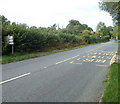
1
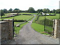
Entrance drive to Porth-elly Farm, Gwehelog
Viewed from Usk Road.
Image: © Jaggery
Taken: 26 Sep 2010
0.05 miles
2
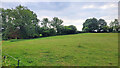
Small field in Gwehelog
This part of Monmouthshire is primarily grazing country.
Image: © Jonathan Billinger
Taken: 28 Jul 2022
0.17 miles
3

Gwehelog Common
Road heading south-east with scattered housing.
Image: © Jonathan Billinger
Taken: 12 Feb 2016
0.18 miles
4
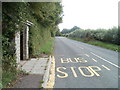
Usk Road heads south from Coldharbour, Gwehelog
The bus stop http://www.geograph.org.uk/photo/2092417 is on the Monmouth - Raglan - Usk - Newport service.
Image: © Jaggery
Taken: 26 Sep 2010
0.19 miles
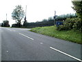
5
Turning for Porth-elly Farm, Gwehelog
Viewed across Usk Road. The farm buildings are about 200 metres away. http://www.geograph.org.uk/photo/2092447
Image: © Jaggery
Taken: 26 Sep 2010
0.19 miles
6
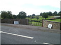
Gwehelog : Usk Road approaches Coldharbour from the south
The bus stops http://www.geograph.org.uk/photo/2092417 http://www.geograph.org.uk/photo/2092412 are about 40 metres apart.
Image: © Jaggery
Taken: 26 Sep 2010
0.19 miles
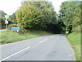
7
Usk Road approaches Coldharbour from the north
Usk Road heading south approaches crossroads and a white-on-blue sign showing Coldharbour.
As I was sure that this is still Gwehelog (it is!), I wondered what name was on the back of the sign http://www.geograph.org.uk/photo/2091381 and also why a place many kilometres inland is considered to be a harbour.
Image: © Jaggery
Taken: 26 Sep 2010
0.19 miles
8
Usk Road approaches Coldharbour from the south
Near the junction of three roads, a white-on-blue sign shows Coldharbour. Confusingly, the way to Coldharbour is not straight ahead, but the turning on the left. The other side of the sign http://www.geograph.org.uk/photo/2091369 also shows Coldharbour.
Image: © Jaggery
Taken: 26 Sep 2010
0.19 miles
9
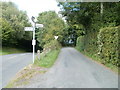
The road to Llandenny from Coldharbour
At Coldharbour, http://www.geograph.org.uk/photo/2091415 two roads join Usk Road. This one is the road to Llandenny, which heads away from the east side of Usk Road, and bends sharply to the right a few metres ahead.
Image: © Jaggery
Taken: 26 Sep 2010
0.19 miles
10
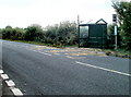
Gwehelog : Coldharbour bus stop on west side of Usk Road
Located near the junction of 3 roads in Coldharbour. 40 metres away, the bus stop on the other side of the road is of a different type. http://www.geograph.org.uk/photo/2092417
Image: © Jaggery
Taken: 26 Sep 2010
0.19 miles