IMAGES TAKEN NEAR TO
Gwehelog, USK, NP15 1RB
Introduction
This page details the photographs taken nearby to NP15 1RB by members of the Geograph project.
The Geograph project started in 2005 with the aim of publishing, organising and preserving representative images for every square kilometre of Great Britain, Ireland and the Isle of Man.

There are currently over 7.5m images from over14,400 individuals and you can help contribute to the project by visiting https://www.geograph.org.uk
Image Map
Images are licensed for reuse under creativecommons.org/licenses/by-sa/2.0
Notes
- Clicking on the map will re-center to the selected point.
- The higher the marker number, the further away the image location is from the centre of the postcode.
Image Listing (43 Images Found)
Images are licensed for reuse under creativecommons.org/licenses/by-sa/2.0
Image
Details
Distance
1
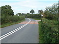
National Speed Limit ahead, Usk Road, Gwehelog
Heading north away from a small cluster of buildings, Usk Road approaches the end of a 40mph speed limit at black-on-white National Speed Limit signs. On the right is the turning http://www.geograph.org.uk/photo/2092534 for Oak Farm.
Image: © Jaggery
Taken: 26 Sep 2010
0.02 miles
2
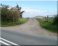
Entrance to Oak Farm, Gwehelog
The entrance is from the east side of Usk Road.
Image: © Jaggery
Taken: 26 Sep 2010
0.02 miles
3
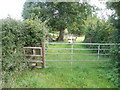
Stile to a footpath with sheep
Close to Shop House, http://www.geograph.org.uk/photo/2092559 a stile next to a gate leads to a footpath on the east side of Usk Road. Sheep are keeping the grass surface of the footpath short.
Image: © Jaggery
Taken: 26 Sep 2010
0.05 miles
4

Shop House, Gwehelog
House on the east side of Usk House, about 70 metres north of the Wainfield Lane junction.
Image: © Jaggery
Taken: 26 Sep 2010
0.05 miles
5
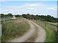
Access lane to Oak Farm, Gwehelog
Access is from the east side of Usk Road. http://www.geograph.org.uk/photo/2092534
Image: © Jaggery
Taken: 26 Sep 2010
0.07 miles
6
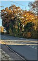
Autumn colours, Gwehelog, Monmouthshire
Viewed across the main road through the village on November 14th 2021.
Image: © Jaggery
Taken: 14 Nov 2021
0.08 miles
7
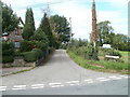
Wainfield Lane, Gwehelog
Viewed from Usk Road. On the left is The Old School. http://www.geograph.org.uk/photo/2092585
Image: © Jaggery
Taken: 26 Sep 2010
0.09 miles
8
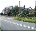
Memories of schooldays, Gwehelog
Houses located on the corner of Usk Road and Wainfield Lane.
On the left is The Masters House. On the right is The Old School.
Image: © Jaggery
Taken: 26 Sep 2010
0.09 miles
9
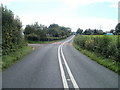
40mph speed limit ahead, Usk Road
On the approach to a small cluster of buildings alongside Usk Road, the speed limit reduces from the National Speed Limit to 40mph. Between the signs, Welsh and English text on the road surface shows ARAF SLOW.
On the left is the entrance http://www.geograph.org.uk/photo/2092534 to the access lane to Oak Farm.
Image: © Jaggery
Taken: 26 Sep 2010
0.09 miles
10
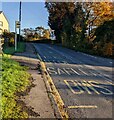
Gwehelog bus stop, Monmouthshire
Located on the main road through Gwehelog opposite the Ty-Freeman Road junction. SAFLE BWS is Welsh for BUS STOP. In November 2021 this is a stop on Newport Bus route 60 from Newport to Monmouth. The Hall Inn https://www.geograph.org.uk/photo/7018773 is behind the camera.
Image: © Jaggery
Taken: 14 Nov 2021
0.10 miles