IMAGES TAKEN NEAR TO
Monmouth Road, USK, NP15 1QX
Introduction
This page details the photographs taken nearby to Monmouth Road, NP15 1QX by members of the Geograph project.
The Geograph project started in 2005 with the aim of publishing, organising and preserving representative images for every square kilometre of Great Britain, Ireland and the Isle of Man.

There are currently over 7.5m images from over14,400 individuals and you can help contribute to the project by visiting https://www.geograph.org.uk
Image Map
Images are licensed for reuse under creativecommons.org/licenses/by-sa/2.0
Notes
- Clicking on the map will re-center to the selected point.
- The higher the marker number, the further away the image location is from the centre of the postcode.
Image Listing (18 Images Found)
Images are licensed for reuse under creativecommons.org/licenses/by-sa/2.0
Image
Details
Distance
1
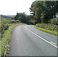
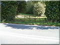
Sharp bend on the descent towards Usk
The white line and broken white line in the centre of Usk Road become double white lines ahead (signifying that vehicles must not cross the lines) at a sharp bend on the approach to the NE edge of residential Usk.
Image: © Jaggery
Taken: 26 Sep 2010
0.08 miles
2
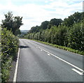
Usk Road heads towards Usk
At this point, Usk Road, from Raglan via Gwehelog, is about 800 metres from the NE edge of residential Usk.
Image: © Jaggery
Taken: 26 Sep 2010
0.08 miles
3
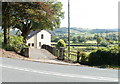
Glen Oak House near Usk
Maps I've consulted do not show at which point Usk Road (from Gwehelog) is renamed Monmouth Road, Usk, so this house's address may be either of these roads. The house is on the south side of the road, about 500 metres east of the NE edge of residential Usk, opposite the shared entrance drive to Braeside and Westwinds.
Image: © Jaggery
Taken: 26 Sep 2010
0.10 miles
4
Shared entrance drive opposite Glen Oak House
Opposite Glen Oak House, http://www.geograph.org.uk/photo/2093336 an entrance drive leads to two houses, Braeside and Westwinds, both set back about 100 metres from the road.
Image: © Jaggery
Taken: 26 Sep 2010
0.10 miles
5
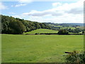
Woodside fields, Usk Road
A break in the trees lining Usk Road gives a view south across fields at the edge of woodland.
Image: © Jaggery
Taken: 26 Sep 2010
0.10 miles
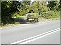
6
Rusty gates, Usk Road
Rusty gates, held together with pink and blue twine, are at the entrance to a field on the east side of Usk Road, about a kilometre NE of the edge of residential Usk.
Image: © Jaggery
Taken: 26 Sep 2010
0.13 miles
7
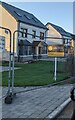
New houses, Monmouth Road, Usk
Detached houses behind temporary fencing in November 2021.
Image: © Jaggery
Taken: 14 Nov 2021
0.13 miles
8
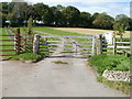
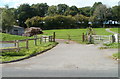
Usk Castle Chase Meadow gate
Adjacent to Usk Road, the gate is at the entrance to a natural burial ground. http://www.geograph.org.uk/photo/2093141
Image: © Jaggery
Taken: 26 Sep 2010
0.18 miles
9
Entrance to natural burial ground, Usk Castle Chase
Located on the north side of Usk Road, about a kilometre NE of the NE edge of residential Usk.
Usk Natural Burial Meadow is a large pasture surrounded on three sides by the woods of Usk Castle Chase. It is intended for simple burials using a coffin or shroud made from natural materials. There are no gravestones nor other markers in the pasture to indicate the exact place of burial. Instead, a certificate is issued after each burial, recording the precise location.
Image: © Jaggery
Taken: 26 Sep 2010
0.18 miles
10
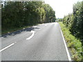
Wandering drivers, Usk Road
From the evidence of the large white arrows on the road surface, it appears that drivers along this section of Usk Road, adjacent to Newbarn Wood, have a tendency to stray to the wrong side of the road.
Image: © Jaggery
Taken: 26 Sep 2010
0.18 miles