IMAGES TAKEN NEAR TO
Kennett Grange, USK, NP15 1QF
Introduction
This page details the photographs taken nearby to Kennett Grange, NP15 1QF by members of the Geograph project.
The Geograph project started in 2005 with the aim of publishing, organising and preserving representative images for every square kilometre of Great Britain, Ireland and the Isle of Man.

There are currently over 7.5m images from over14,400 individuals and you can help contribute to the project by visiting https://www.geograph.org.uk
Image Map
Images are licensed for reuse under creativecommons.org/licenses/by-sa/2.0
Notes
- Clicking on the map will re-center to the selected point.
- The higher the marker number, the further away the image location is from the centre of the postcode.
Image Listing (132 Images Found)
Images are licensed for reuse under creativecommons.org/licenses/by-sa/2.0
Image
Details
Distance
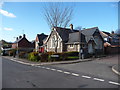
1
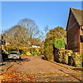
Kennett Grange, Llangybi, Monmouthshire
Cul-de-sac viewed from the corner of Ton Road in November 2021.
Image: © Jaggery
Taken: 21 Nov 2021
0.01 miles
2
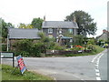
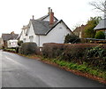
Albert Cottage, Llangybi
Located on the corner of Ton Road and the main road through the village.
Image: © Jaggery
Taken: 15 May 2011
0.02 miles
3
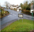
Ton Road, Llangybi
Ton Road heads SW away from the main road through the village.
Image: © Jaggery
Taken: 15 May 2011
0.02 miles
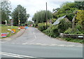
4
Parc Road, Llangybi
Viewed across the main road through the village. The sign on the left shows Llandegvedd Reservoir 3½ miles.
Image: © Jaggery
Taken: 15 May 2011
0.02 miles
5
Llangybi Village Hall
Located on Ton Road. Regular users of the hall shown on the hall's noticeboard in early February 2012:
Tuesday mornings: Yoga 9.30 to 11
Tuesday evenings: Llangybi Fawr Community Council (3rd Tues in month)
Thursday afternoons: Age Concern 2 to 4
Thursday evenings: Women's Institute 7.30 (2nd Thurs in month)
Fridays: Art Class 10.30am to 4pm (1st Fri in month).
The hall is available for hire for the days or times not shown above.
Image: © Jaggery
Taken: 6 Feb 2012
0.02 miles
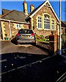
6
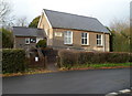
Grade II listed former village school, Llangybi
Now a private residence, Graigwen, this building on Ton Road used to be the village school. The wing nearest the camera is an 1874 extension to the original building behind it, which dates from 1831.
Grade II listed in November 1980.
Image: © Jaggery
Taken: 6 Feb 2012
0.02 miles
7
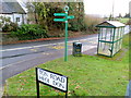
Old-style road sign, Llangybi
Located at the eastern end of Ton Road, at the junction with the main road through the village.
An arrow points left for Llanbadoc 2 miles, Usk 2½, Little Mill 6.
Another arrow points right for Newbridge-on-Usk 2½ and Caerleon 5.
At the right edge of the view are recently-installed green signs. http://www.geograph.org.uk/photo/2793710
Image: © Jaggery
Taken: 6 Feb 2012
0.02 miles
8
Recently-installed signs, Llangybi
The green signs are on the corner of Ton Road and the main road through the village. A few metres behind the camera are old-style signs http://www.geograph.org.uk/photo/2793681 of a type once commonplace but now rarely seen.
Image: © Jaggery
Taken: 6 Feb 2012
0.02 miles
9
Llangibby village school, now converted to a home
The old village infant's school has been converted to a residence. With a development of houses on the old school grounds.
Image: © Jeremy Bolwell
Taken: 25 Feb 2012
0.02 miles
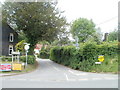
10
Stone building, Ton Road, Llangybi
The Ton Road side of the building on the corner of the cul-de-sac Kennett Grange.
Perhaps a converted former school?
Image: © Jaggery
Taken: 21 Nov 2021
0.02 miles