IMAGES TAKEN NEAR TO
Llangybi, USK, NP15 1PJ
Introduction
This page details the photographs taken nearby to NP15 1PJ by members of the Geograph project.
The Geograph project started in 2005 with the aim of publishing, organising and preserving representative images for every square kilometre of Great Britain, Ireland and the Isle of Man.

There are currently over 7.5m images from over14,400 individuals and you can help contribute to the project by visiting https://www.geograph.org.uk
Image Map
Images are licensed for reuse under creativecommons.org/licenses/by-sa/2.0
Notes
- Clicking on the map will re-center to the selected point.
- The higher the marker number, the further away the image location is from the centre of the postcode.
Image Listing (130 Images Found)
Images are licensed for reuse under creativecommons.org/licenses/by-sa/2.0
Image
Details
Distance
1
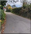
Hedge-lined Parc Road, Llangybi, Monmouthshire
Parc Road ascends from Usk Road, the main road through Llangybi.
Image: © Jaggery
Taken: 19 Nov 2021
0.01 miles
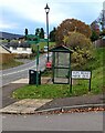
2
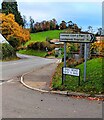
Direction and distances sign on a Llangybi corner, Monmouthshire
On the corner of Usk Road and Parc Road (Heol y Parc in Welsh)
3 (miles) from Common Coed-y-Paen, 3½ from Llandegvedd Reservoir.
Image: © Jaggery
Taken: 19 Nov 2021
0.02 miles
3
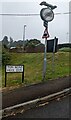
Warning sign - hedgehogs, Ton Road, Llangybi
Recently installed sign opposite the main road through Llangybi in rural Monmouthshire viewed in August 2022. Ton Road is Heol Don in Welsh.
Image: © Jaggery
Taken: 21 Aug 2022
0.02 miles
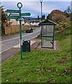
4
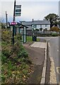
Llangybi bus stop and shelter, Monmouthshire
Alongside Usk Road near the Ton Road junction. In November 2021 this is a stop on bus route 60 from Newport to Usk and Monmouth.
Image: © Jaggery
Taken: 19 Nov 2021
0.03 miles
5
Bilingual road name sign, Llangybi, Monmouthshire
The sign near the Usk Road junction shows that Ton Road is Heol Don in Welsh.
Image: © Jaggery
Taken: 19 Nov 2021
0.03 miles
6
Green signpost, Usk Road, Llangybi, Monmouthshire
Pointing the way to Llangybi Church, Llangybi Well, Llangybi Village Hall.
Image: © Jaggery
Taken: 19 Nov 2021
0.03 miles
7
Llangybi 2001 sign, Monmouthshire
Viewed across Usk Road in November 2021. The sign showing LLANGYBI 2001 is not in an August 2016 Google Street View of this location.
Image: © Jaggery
Taken: 19 Nov 2021
0.03 miles
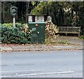
8
Yellow box on the Village Hall wall, Llangybi
The box contains a defibrillator for use in a potentially life-threatening emergency. The defibrillator applies a therapeutic electric current to the chest or heart to stop irregular contractions, or fibrillation, of the heart.
Image: © Jaggery
Taken: 21 Nov 2021
0.03 miles
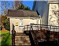
9
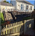
Steps up to the Village Hall, Llangybi
From Ton Road. Ramp access is on the right.
Image: © Jaggery
Taken: 21 Nov 2021
0.03 miles
10
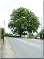
Oak tree, Llangybi
The tree, on the side of the main road through the village, is a few metres north of The White Hart Village Inn. http://www.geograph.org.uk/photo/2410670
Image: © Jaggery
Taken: 15 May 2011
0.03 miles