IMAGES TAKEN NEAR TO
Ton Road, USK, NP15 1PA
Introduction
This page details the photographs taken nearby to Ton Road, NP15 1PA by members of the Geograph project.
The Geograph project started in 2005 with the aim of publishing, organising and preserving representative images for every square kilometre of Great Britain, Ireland and the Isle of Man.

There are currently over 7.5m images from over14,400 individuals and you can help contribute to the project by visiting https://www.geograph.org.uk
Image Map
Images are licensed for reuse under creativecommons.org/licenses/by-sa/2.0
Notes
- Clicking on the map will re-center to the selected point.
- The higher the marker number, the further away the image location is from the centre of the postcode.
Image Listing (126 Images Found)
Images are licensed for reuse under creativecommons.org/licenses/by-sa/2.0
Image
Details
Distance
1
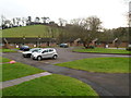
Western section of Glanynant, Llangybi
Viewed from Ton Road. This section of Glanynant contains bungalows numbered from 1 to 15.
Image: © Jaggery
Taken: 6 Feb 2012
0.02 miles
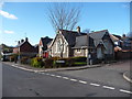
2
Corner house, Kennett Grange, Llangybi
The stone house on the corner of Ton Road and Kennett Grange is distinctly different from, and looks much older than, the other houses in Kennett Grange, a short cul-de-sac.
Image: © Jaggery
Taken: 6 Feb 2012
0.02 miles
3
Two houses, Kennett Grange, Llangybi
Though on Ton Road, these two houses are numbered as part of Kennett Grange, a short cul-de-sac out of shot beyond the right edge of the view.
Image: © Jaggery
Taken: 6 Feb 2012
0.02 miles
4
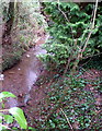
St Cybi's Brook, Llangybi
The brook, a minor tributary of the River Usk, flows away from Ton Road.
Image: © Jaggery
Taken: 6 Feb 2012
0.02 miles
5
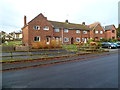
Short row of houses, Ton Road, Llangybi
The houses are located between St Cybi Avenue http://www.geograph.org.uk/photo/2793973 and Catherine Cottages. http://www.geograph.org.uk/photo/2793984
Image: © Jaggery
Taken: 6 Feb 2012
0.02 miles
6
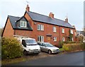
Catherine Cottages, Llangybi
Two semi-detached cottages on the north side of Ton Road.
Image: © Jaggery
Taken: 6 Feb 2012
0.02 miles
7
Eastern half of Glanynant, Llangybi
Viewed from Ton Road. This section of Glanynant contains bungalows numbered from 16 to 37.
Image: © Jaggery
Taken: 6 Feb 2012
0.04 miles
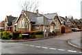
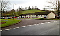
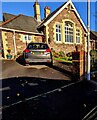
8
Llangibby village school, now converted to a home
The old village infant's school has been converted to a residence. With a development of houses on the old school grounds.
Image: © Jeremy Bolwell
Taken: 25 Feb 2012
0.06 miles
9
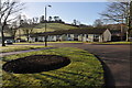
Glanynant, Llangybi
Bungalows in Glanynant in Llangybi.
Image: © Philip Halling
Taken: 12 Feb 2011
0.07 miles
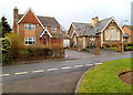
10
Stone building, Ton Road, Llangybi
The Ton Road side of the building on the corner of the cul-de-sac Kennett Grange.
Perhaps a converted former school?
Image: © Jaggery
Taken: 21 Nov 2021
0.07 miles