IMAGES TAKEN NEAR TO
Llangeview, USK, NP15 1NF
Introduction
This page details the photographs taken nearby to NP15 1NF by members of the Geograph project.
The Geograph project started in 2005 with the aim of publishing, organising and preserving representative images for every square kilometre of Great Britain, Ireland and the Isle of Man.

There are currently over 7.5m images from over14,400 individuals and you can help contribute to the project by visiting https://www.geograph.org.uk
Image Map
Images are licensed for reuse under creativecommons.org/licenses/by-sa/2.0
Notes
- Clicking on the map will re-center to the selected point.
- The higher the marker number, the further away the image location is from the centre of the postcode.
Image Listing (9 Images Found)
Images are licensed for reuse under creativecommons.org/licenses/by-sa/2.0
Image
Details
Distance
1
Unsuitable for heavy goods vehicles
The signs reads 'Unsuitable for heavy goods vehicles', I not sure it is even a through road having looked at the OS map. Pictured at a country road junction at Coed Cwnwr.
Image: © Philip Halling
Taken: 15 Jun 2018
0.07 miles
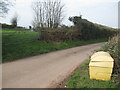
3
Pastoral land
View north of Alltybela Road at Coed-Cwnwr.
Image: © Jonathan Billinger
Taken: 3 Dec 2014
0.14 miles
4
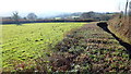
Hedge alongside Gwern Ddu Road
Viewed from the stile on the footpath in Image
Note the width of the low-cut hedge and the deep cut of the road to the right.
Image: © Jonathan Billinger
Taken: 3 Dec 2014
0.15 miles
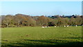
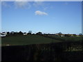
6
Pasture at Ty-Wilson
A footpath leads straight across the field to the gap at the far side.
Image: © Jonathan Billinger
Taken: 3 Dec 2014
0.16 miles
7
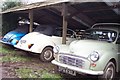
Moggies in hiding
At Coed-Cwnwr Farm
Image: © Jonathan Billinger
Taken: 27 Dec 2006
0.20 miles
8
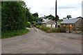
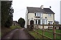
Coed Cwnwr
Coed Cwnwr farm and surrounding properties
Image: © Andrew Lewis
Taken: 7 Mar 2008
0.20 miles
9
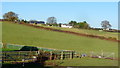
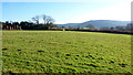
Pastures at Coed-Cwnwr
Coed-Cwnwr Farm on the hillside to the left.
Image: © Jonathan Billinger
Taken: 3 Dec 2014
0.20 miles