IMAGES TAKEN NEAR TO
Penycaemawr, USK, NP15 1NA
Introduction
This page details the photographs taken nearby to NP15 1NA by members of the Geograph project.
The Geograph project started in 2005 with the aim of publishing, organising and preserving representative images for every square kilometre of Great Britain, Ireland and the Isle of Man.

There are currently over 7.5m images from over14,400 individuals and you can help contribute to the project by visiting https://www.geograph.org.uk
Image Map
Images are licensed for reuse under creativecommons.org/licenses/by-sa/2.0
Notes
- Clicking on the map will re-center to the selected point.
- The higher the marker number, the further away the image location is from the centre of the postcode.
Image Listing (6 Images Found)
Images are licensed for reuse under creativecommons.org/licenses/by-sa/2.0
Image
Details
Distance
1
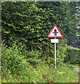
Warning sign - minor crossroads, Usk Road, Wentwood
Facing westbound traffic.
Image: © Jaggery
Taken: 13 Aug 2023
0.05 miles
2
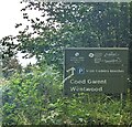
Cadeira Beeches Car Park direction sign, Wentwood
Alongside Usk Road half a mile from the car park. https://www.geograph.org.uk/photo/7569752
Wentwood is Coed Gwent in Welsh.
Image: © Jaggery
Taken: 13 Aug 2023
0.08 miles
3
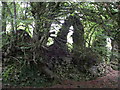
Cas Troggy
The remains of the medieval Cas Troggi, built for the Bigods but only in use for a mere 13 years.
Image: © Simon Leatherdale
Taken: 28 Sep 2007
0.10 miles
4
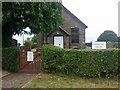
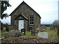
Pencaemawr Methodist Chapel
Tiny chapel is still in use although it would seem to be a very isolated scattered parish at the top of the Wentwood Hills.
The windows have been replaced since Image, the First Geograph for the square, was taken in 2006.
Image: © Jonathan Billinger
Taken: 11 Jul 2018
0.20 miles
6
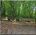
Boulders above the south side of Usk Road, Wentwood
Preventing vehicular ingress into the forest.
Image: © Jaggery
Taken: 13 Aug 2023
0.25 miles