IMAGES TAKEN NEAR TO
Llantrisant, USK, NP15 1LW
Introduction
This page details the photographs taken nearby to NP15 1LW by members of the Geograph project.
The Geograph project started in 2005 with the aim of publishing, organising and preserving representative images for every square kilometre of Great Britain, Ireland and the Isle of Man.

There are currently over 7.5m images from over14,400 individuals and you can help contribute to the project by visiting https://www.geograph.org.uk
Image Map
Images are licensed for reuse under creativecommons.org/licenses/by-sa/2.0
Notes
- Clicking on the map will re-center to the selected point.
- The higher the marker number, the further away the image location is from the centre of the postcode.
Image Listing (4 Images Found)
Images are licensed for reuse under creativecommons.org/licenses/by-sa/2.0
Image
Details
Distance
2
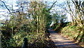
Nant-y-banw Lane
The Llantrisant Brook runs alongside to the left.
Image: © Jonathan Billinger
Taken: 3 Dec 2014
0.16 miles
3
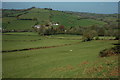
View north from Corn Hill
Gwern-Ddu Hill viewed from Corn Hill.
Image: © Philip Halling
Taken: 19 Apr 2009
0.20 miles
4
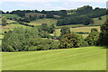
View towards Gwernddu & Gwern Ddu Wood
Looking across from the Usk Valley Walk on the flank of Corn Hill.
Image: © M J Roscoe
Taken: 14 Jul 2021
0.23 miles