IMAGES TAKEN NEAR TO
Trostrey, USK, NP15 1LD
Introduction
This page details the photographs taken nearby to NP15 1LD by members of the Geograph project.
The Geograph project started in 2005 with the aim of publishing, organising and preserving representative images for every square kilometre of Great Britain, Ireland and the Isle of Man.

There are currently over 7.5m images from over14,400 individuals and you can help contribute to the project by visiting https://www.geograph.org.uk
Image Map
Images are licensed for reuse under creativecommons.org/licenses/by-sa/2.0
Notes
- Clicking on the map will re-center to the selected point.
- The higher the marker number, the further away the image location is from the centre of the postcode.
Image Listing (11 Images Found)
Images are licensed for reuse under creativecommons.org/licenses/by-sa/2.0
Image
Details
Distance
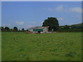
1
Light aircraft landing at Little Trostrey
Image: © Philip Halling
Taken: 26 Apr 2009
0.08 miles
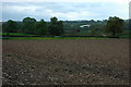
2
Ploughed field at Little Trostrey
Ploughed field at Little Trostrey in the Usk valley.
Image: © Philip Halling
Taken: 26 Apr 2009
0.12 miles
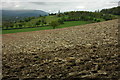
3
New grass landing strip near Kemeys Commander
View looks north-westwards with the Blorenge (and Brecon Beacons) in the far background. The alignment of the airstrip is clearly visible through the shorter grass but there are also white markers on each side to aid the pilot. The orange windsock indicating a north-easterly breeze is just to the left of the barns.
Image: © Roger Davies
Taken: 6 Apr 2008
0.12 miles
5
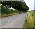
B4598 southeast of Kemeys Commander, Monmouthshire
Ahead for Llancayo and Usk. A Kemeys Commander village boundary sign https://www.geograph.org.uk/photo/6909656 is behind the camera.
Image: © Jaggery
Taken: 25 Jul 2021
0.13 miles
6
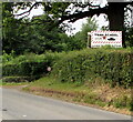
Tank School nameboard, Kemeys Commander, Monmouthshire
The board above the B4598 shows TANK SCHOOL - Learn to drive a tank.
Image: © Jaggery
Taken: 25 Jul 2021
0.13 miles
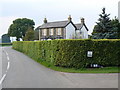
7
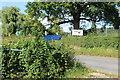
Signs on approach to Kemeys Commander
Approach from the south on B4598 to village. The green footpath sign is next to an overgrown impassable stile.
Image: © M J Roscoe
Taken: 15 Sep 2021
0.14 miles
8
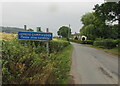
KEMEYS COMMANDER - Please drive carefully
Monmouthshire village boundary sign alongside the B4598.
Image: © Jaggery
Taken: 25 Jul 2021
0.14 miles
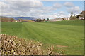
10
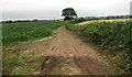
Track past fields, Kemeys Commander, Monmouthshire
On the SW side of the B4598, the main road through Kemeys Commander.
The village boundary sign https://www.geograph.org.uk/photo/6909656 is near the camera.
Image: © Jaggery
Taken: 25 Jul 2021
0.17 miles