IMAGES TAKEN NEAR TO
Trostrey, USK, NP15 1LA
Introduction
This page details the photographs taken nearby to NP15 1LA by members of the Geograph project.
The Geograph project started in 2005 with the aim of publishing, organising and preserving representative images for every square kilometre of Great Britain, Ireland and the Isle of Man.

There are currently over 7.5m images from over14,400 individuals and you can help contribute to the project by visiting https://www.geograph.org.uk
Image Map
Images are licensed for reuse under creativecommons.org/licenses/by-sa/2.0
Notes
- Clicking on the map will re-center to the selected point.
- The higher the marker number, the further away the image location is from the centre of the postcode.
Image Listing (5 Images Found)
Images are licensed for reuse under creativecommons.org/licenses/by-sa/2.0
Image
Details
Distance
1

Dead-end lane
Leads to Hill Farm, passing a house named Pleasant View seen to the left.
Image: © Jonathan Billinger
Taken: 12 Feb 2016
0.12 miles
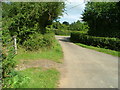
2

Lane by Long Wood Farm
Narrow lane heads north towards Berllwyd.
Image: © Jonathan Billinger
Taken: 12 Feb 2016
0.14 miles
3

Track and bridleway
Towards Walnut Tree House, Trostrey Common.
Image: © Jonathan Billinger
Taken: 12 Feb 2016
0.17 miles
4
Road junction at Trostrey Common
Image: © Nick Mutton 01329 000000
Taken: 2 Sep 2007
0.18 miles
5

Gate and stile
Plus a reminder for dog owners to keep their animals on a lead.
Image: © Jonathan Billinger
Taken: 12 Feb 2016
0.18 miles