IMAGES TAKEN NEAR TO
Llangwm, USK, NP15 1HG
Introduction
This page details the photographs taken nearby to NP15 1HG by members of the Geograph project.
The Geograph project started in 2005 with the aim of publishing, organising and preserving representative images for every square kilometre of Great Britain, Ireland and the Isle of Man.

There are currently over 7.5m images from over14,400 individuals and you can help contribute to the project by visiting https://www.geograph.org.uk
Image Map
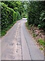
Images are licensed for reuse under creativecommons.org/licenses/by-sa/2.0
Notes
- Clicking on the map will re-center to the selected point.
- The higher the marker number, the further away the image location is from the centre of the postcode.
Image Listing (113 Images Found)
Images are licensed for reuse under creativecommons.org/licenses/by-sa/2.0
Image
Details
Distance
1
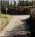
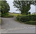
Junction of Chapel Road and Llanynant Road, Llangwm, Monmouthshire
The Give Way sign on the corner of Llanynant Road faces Chapel Road.
Image: © Jaggery
Taken: 25 Mar 2018
0.00 miles
2
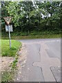
Give Way sign, Chapel Road, Llangwm, Monmouthshire
At the Llanynant Road junction. Turn left for the B4235, the main road through Llangwm.
Image: © Jaggery
Taken: 29 Aug 2021
0.00 miles
3
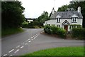
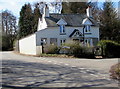
Cottage in Llangwm
Cottage on the corner of Chapel Road and Llanynant Road in Llangwm.
Image: © Philip Halling
Taken: 15 Jun 2018
0.00 miles
4
No Through Road sign at the eastern end of Chapel Road, Llangwm, Monmouthshire
Facing Llanynant Road. Chapel Road extends ahead for 120 metres to the entrance https://www.geograph.org.uk/photo/5720377 to Chapel Farm.
Image: © Jaggery
Taken: 25 Mar 2018
0.01 miles
5
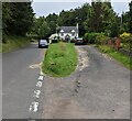
Llan y Nant Cottage, Llangwm, Monmouthshire
On the corner of Llanynant Road and Chapel Road.
Image: © Jaggery
Taken: 25 Mar 2018
0.01 miles
6
Shades of yellow, Llanynant Road, Llangwm, Monmouthshire
A vivid yellow panel over a hydrant is near a pale yellow salt/grit box. A yellow hydrant marker is behind the box.
Image: © Jaggery
Taken: 29 Aug 2021
0.01 miles
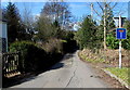
7
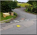
Grass strip, Llanynant Road, Llangwm, Monmouthshire
On the approach to the Chapel Road junction. Llan y Nant Cottage is in the background. https://www.geograph.org.uk/photo/5720356
Image: © Jaggery
Taken: 29 Aug 2021
0.01 miles
8
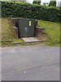
Llangwm Village electricity substation, Monmouthshire
Western Power Distribution electricity substation alongside Llanynant Road.
The substation identifier is LLANGWM VILLAGE S/S No. 535581.
Image: © Jaggery
Taken: 29 Aug 2021
0.01 miles
9
West along Chapel Road, Llangwm, Monmouthshire
From Llanynant Road, Chapel Road leads to Salem Baptist Chapel. https://www.geograph.org.uk/photo/5720386
Image: © Jaggery
Taken: 29 Aug 2021
0.02 miles
10
Side roads in Llangwm, Monmouthshire
Viewed across Llanynant Road.
Image: © Jaggery
Taken: 29 Aug 2021
0.02 miles