IMAGES TAKEN NEAR TO
Llandenny, USK, NP15 1DL
Introduction
This page details the photographs taken nearby to NP15 1DL by members of the Geograph project.
The Geograph project started in 2005 with the aim of publishing, organising and preserving representative images for every square kilometre of Great Britain, Ireland and the Isle of Man.

There are currently over 7.5m images from over14,400 individuals and you can help contribute to the project by visiting https://www.geograph.org.uk
Image Map
Images are licensed for reuse under creativecommons.org/licenses/by-sa/2.0
Notes
- Clicking on the map will re-center to the selected point.
- The higher the marker number, the further away the image location is from the centre of the postcode.
Image Listing (47 Images Found)
Images are licensed for reuse under creativecommons.org/licenses/by-sa/2.0
Image
Details
Distance
1
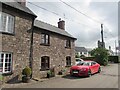
The Old Post Office, Llandenny, Monmouthshire
The car is parked outside the house named The Old Post Office in July 2021.
Image: © Jaggery
Taken: 11 Jul 2021
0.02 miles
2
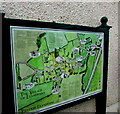
Village map and information, Llandenny, Monmouthshire
The map located here https://www.geograph.org.uk/photo/7491808 shows the location of places of interest in the village and some details, such as The Village Well which until mains water came to the village in the mid 1950s was the main source of water for village inhabitants. Text in the lower left corner of the map shows that THE VILLAGE OF LLANDENNY is PENTREF LLANDENNI in Welsh.
Image: © Jaggery
Taken: 11 Jul 2021
0.02 miles
3
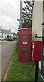
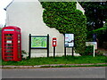
Reds on green, Llandenny, Monmouthshire
Beyond a red postbox, a notice on the former red phonebox in July 2021 shows
"This Book Exchange is accepting no EXTRA books until further notice so please
only leave books if you are taking away AT LEAST the same number of books"
Image: © Jaggery
Taken: 11 Jul 2021
0.02 miles
4
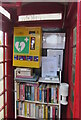
Inside a former red phonebox, Llandenny, Monmouthshire
In July 2021 the box located here https://www.geograph.org.uk/photo/7491808 contains a small library and a defibrillator box.
Image: © Jaggery
Taken: 11 Jul 2021
0.02 miles
5
Greens and reds, Llandenny, Monmouthshire
A red postbox is in the middle. In July 2021 the red former
phonebox houses a small library and a defibrillator box. https://www.geograph.org.uk/photo/7491813
Image: © Jaggery
Taken: 11 Jul 2021
0.02 miles
6
Raglan Arms, Llandenny, Monmouthshire
Pub alongside the main road through the village viewed in July 2021.
The tower of St John's Church is in the background.
Image: © Jaggery
Taken: 11 Jul 2021
0.02 miles
7
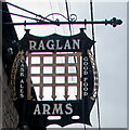
Raglan Arms name sign, Llandenny, Monmouthshire
The sign on a pole projecting from the wall here https://www.geograph.org.uk/photo/6895060 shows CASK ALES and GOOD FOOD in July 2021.
Image: © Jaggery
Taken: 11 Jul 2021
0.02 miles
8
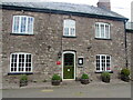
Dark green door, Llandenny, Monmouthshire
The entrance door to the Raglan Arms https://www.geograph.org.uk/photo/6895060
A red Michelin 2019 https://www.geograph.org.uk/photo/6895078 sign is on the wall on the left side of the door.
Image: © Jaggery
Taken: 11 Jul 2021
0.02 miles
9
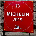
Michelin 2019 sign, Llandenny, Monmouthshire
Located here https://www.geograph.org.uk/photo/6895074 on the wall of the Raglan Arms.
Image: © Jaggery
Taken: 11 Jul 2021
0.02 miles
10
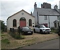
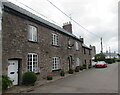
The Coach House, Llandenny, Monmouthshire
The Old Vicarage https://www.geograph.org.uk/photo/6895038 is on the right.
Image: © Jaggery
Taken: 11 Jul 2021
0.02 miles