IMAGES TAKEN NEAR TO
Llandenny, USK, NP15 1DD
Introduction
This page details the photographs taken nearby to NP15 1DD by members of the Geograph project.
The Geograph project started in 2005 with the aim of publishing, organising and preserving representative images for every square kilometre of Great Britain, Ireland and the Isle of Man.

There are currently over 7.5m images from over14,400 individuals and you can help contribute to the project by visiting https://www.geograph.org.uk
Image Map
Images are licensed for reuse under creativecommons.org/licenses/by-sa/2.0
Notes
- Clicking on the map will re-center to the selected point.
- The higher the marker number, the further away the image location is from the centre of the postcode.
Image Listing (11 Images Found)
Images are licensed for reuse under creativecommons.org/licenses/by-sa/2.0
Image
Details
Distance
1
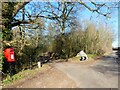
Post box, and drive to Cefntilla Court, near Llandenny
Image: © Ruth Sharville
Taken: 7 Feb 2023
0.08 miles
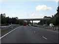
2
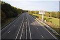
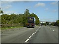
The A449
View towards Monmouth along the A449 dual carriageway, pictured here from a bridge to the south of village of Llandenny.
Image: © Philip Halling
Taken: 20 Oct 2012
0.09 miles
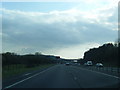
3
Raglan : A449
Looking along the A449 dual carriageway.
Image: © Lewis Clarke
Taken: 22 Mar 2023
0.11 miles
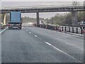
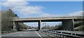
5
A449 - minor road overbridge near Lanolway Farm
Image: © J Whatley
Taken: 31 Aug 2010
0.13 miles
9
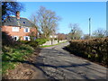
Dwellings on the road towards Llandenny
Image: © Ruth Sharville
Taken: 7 Feb 2023
0.18 miles
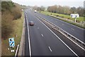
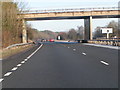
10
Lay-by and minor road crossing A449 near Lanolway Farm
Image: © David Smith
Taken: 29 Sep 2016
0.19 miles