IMAGES TAKEN NEAR TO
Black Barn Close, USK, NP15 1BS
Introduction
This page details the photographs taken nearby to Black Barn Close, NP15 1BS by members of the Geograph project.
The Geograph project started in 2005 with the aim of publishing, organising and preserving representative images for every square kilometre of Great Britain, Ireland and the Isle of Man.

There are currently over 7.5m images from over14,400 individuals and you can help contribute to the project by visiting https://www.geograph.org.uk
Image Map
Images are licensed for reuse under creativecommons.org/licenses/by-sa/2.0
Notes
- Clicking on the map will re-center to the selected point.
- The higher the marker number, the further away the image location is from the centre of the postcode.
Image Listing (291 Images Found)
Images are licensed for reuse under creativecommons.org/licenses/by-sa/2.0
Image
Details
Distance
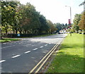
1
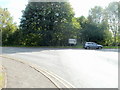
End of a short one-way section, Monmouth Road, Usk
A one-way section http://www.geograph.org.uk/photo/2094105 of road ends at the junction with the A472
Image: © Jaggery
Taken: 26 Sep 2010
0.03 miles
2
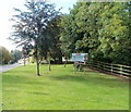
Usk - town of flowers
A large sign on the grass verge on the north side of the A472 proclaims
USK
TOWN OF FLOWERS
Winners "Wales in Bloom" and "Britain in Bloom"
Of course, there is much more than pretty flowers to see in Usk...
Image: © Jaggery
Taken: 26 Sep 2010
0.03 miles
3
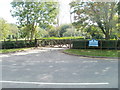
Main entrance to Usk Church in Wales Primary School
Located on the southern side of the A472, here named Monmouth Road.
Image: © Jaggery
Taken: 26 Sep 2010
0.03 miles
4
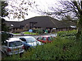
Usk Church in Wales Primary School
Photo taken from the verge of the A472.
Image: © Jonathan Billinger
Taken: 21 Nov 2007
0.05 miles
5
Usk Church in Wales Primary School entrance
Below the south side of the A472 in Usk.
Image: © Jaggery
Taken: 3 Nov 2018
0.06 miles
6

Four flags and flagpoles in the grounds of an Usk school
In the grounds of Usk Church in Wales Primary School viewed across the A472.
Image: © Jaggery
Taken: 3 Nov 2018
0.06 miles
7
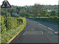
A472 heads away east from Usk
The 30mph speed limit along the A472 in Usk ends at National Speed Limit signs.
Viewed from the corner of Monmouth Road.
Image: © Jaggery
Taken: 26 Sep 2010
0.07 miles
8
Looking down Chepstow Road towards Usk / Brynbuga
Taken near 'Davington', home of 'JUST ICE'
Image: © Ian Paterson
Taken: 1 May 2007
0.07 miles
9
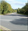
West along the A472, Usk
This part of the A472, at the eastern edge of Usk, is unnamed.
A little out of shot ahead, it becomes the A472 Monmouth Road.
Double yellow lines on both sides of the road indicate no parking at any time.
Image: © Jaggery
Taken: 3 Nov 2018
0.07 miles
10
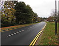
Monmouth Road heads into Usk
The A472, here named Monmouth Road, heads towards the centre of Usk.
On the left is the main entrance to Usk Church in Wales Primary School. http://www.geograph.org.uk/photo/2094160
Image: © Jaggery
Taken: 26 Sep 2010
0.07 miles