IMAGES TAKEN NEAR TO
Priory Gardens, USK, NP15 1BB
Introduction
This page details the photographs taken nearby to Priory Gardens, NP15 1BB by members of the Geograph project.
The Geograph project started in 2005 with the aim of publishing, organising and preserving representative images for every square kilometre of Great Britain, Ireland and the Isle of Man.

There are currently over 7.5m images from over14,400 individuals and you can help contribute to the project by visiting https://www.geograph.org.uk
Image Map
Images are licensed for reuse under creativecommons.org/licenses/by-sa/2.0
Notes
- Clicking on the map will re-center to the selected point.
- The higher the marker number, the further away the image location is from the centre of the postcode.
Image Listing (717 Images Found)
Images are licensed for reuse under creativecommons.org/licenses/by-sa/2.0
Image
Details
Distance
1
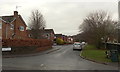
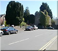
Priory Gardens, Usk
The name sign on the left, on the corner of Maryport Street, shows 29-61 Priory Gardens.
Image: © Jaggery
Taken: 14 Dec 2014
0.03 miles
2
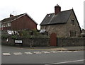
Priory Lodge, Usk
On the corner of Priory Gardens and Maryport Street.
Image: © Jaggery
Taken: 27 Nov 2016
0.05 miles
3
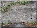
Ordnance Survey Cut Mark
This OS cut mark can be found on the wall of No24 Maryport Street. It marks a point 17.219m above mean sea level.
Image: © Adrian Dust
Taken: 8 Oct 2022
0.05 miles
4
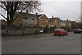
Priory Gardens houses, Usk
This part of Priory Gardens (numbers 22-28) is alongside Maryport Street.
Image: © Jaggery
Taken: 27 Nov 2016
0.05 miles
5
Grade I listed Priory Gatehouse, Usk
Probably dating from the early 16th century, the gatehouse is located on the corner of Church Street and Priory Street, at the southern entrance to the churchyard of the Priory Church of St Mary.
The gatehouse was Grade I listed in 1953.
Image: © Jaggery
Taken: 8 Apr 2011
0.06 miles
6
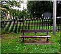
Bench on grass, Priory Gardens, Usk, Monmouthshire
Located here https://www.geograph.org.uk/photo/6732151 near the corner of Maryport Street.
Image: © Jaggery
Taken: 23 Aug 2020
0.06 miles
7
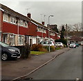
Priory Gardens houses in Usk
Viewed from the Maryport Street end.
The tower of the Grade I listed Priory Church of St Mary http://www.geograph.org.uk/photo/2429231 is in the background.
Image: © Jaggery
Taken: 14 Dec 2014
0.06 miles
8
Priory Gardens, Usk
Viewed across Maryport Street.
Image: © Jaggery
Taken: 27 Nov 2016
0.06 miles

10
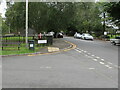
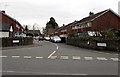
Junction of Priory Gardens and Maryport Street, Usk, Monmouthshire
From the left, the road named Priory Gardens joins Maryport Street.
Image: © Jaggery
Taken: 23 Aug 2020
0.06 miles