IMAGES TAKEN NEAR TO
Cwmcelyn Newydd, ABERTILLERY, NP13 3LS
Introduction
This page details the photographs taken nearby to Cwmcelyn Newydd, NP13 3LS by members of the Geograph project.
The Geograph project started in 2005 with the aim of publishing, organising and preserving representative images for every square kilometre of Great Britain, Ireland and the Isle of Man.

There are currently over 7.5m images from over14,400 individuals and you can help contribute to the project by visiting https://www.geograph.org.uk
Image Map
Images are licensed for reuse under creativecommons.org/licenses/by-sa/2.0
Notes
- Clicking on the map will re-center to the selected point.
- The higher the marker number, the further away the image location is from the centre of the postcode.
Image Listing (9 Images Found)
Images are licensed for reuse under creativecommons.org/licenses/by-sa/2.0
Image
Details
Distance

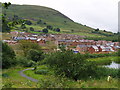
2
Footbridge over Cwmcelyn Pond, Blaina
Bridge over Cwmcelyn Pond, Blaina, with new housing on Mynydd James in the background.
Image: © Martin Speck
Taken: 18 Apr 2013
0.07 miles
3
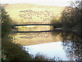
Bridge over Cwmcelyn Pond, Blaina.
Mynydd Carn-y Cefn in the background
Image: © Ebbw Fach
Taken: 11 Apr 2009
0.08 miles
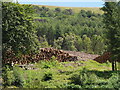
6

Cwmcelyn Pond, Blaina.
This pond was once a feeder pond for local collieries, now it is stocked with fish and a home for Mallard and Moorhen, a pair of Mallard can just be seen just off centre.
Image: © Ebbw Fach
Taken: 2 Mar 2009
0.13 miles
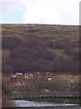
7
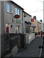
Blaina: Cwmcelyn Post Office
This branch is threatened with closure in the spring of 2008.
Image: © Chris Downer
Taken: 16 Feb 2008
0.14 miles