IMAGES TAKEN NEAR TO
Waengron, ABERTILLERY, NP13 3LP
Introduction
This page details the photographs taken nearby to Waengron, NP13 3LP by members of the Geograph project.
The Geograph project started in 2005 with the aim of publishing, organising and preserving representative images for every square kilometre of Great Britain, Ireland and the Isle of Man.

There are currently over 7.5m images from over14,400 individuals and you can help contribute to the project by visiting https://www.geograph.org.uk
Image Map
Images are licensed for reuse under creativecommons.org/licenses/by-sa/2.0
Notes
- Clicking on the map will re-center to the selected point.
- The higher the marker number, the further away the image location is from the centre of the postcode.
Image Listing (36 Images Found)
Images are licensed for reuse under creativecommons.org/licenses/by-sa/2.0
Image
Details
Distance
1
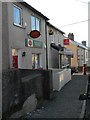
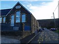
Blaina: Cwmcelyn Post Office
This branch is threatened with closure in the spring of 2008.
Image: © Chris Downer
Taken: 16 Feb 2008
0.05 miles
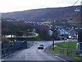
6
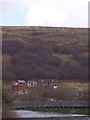
Footbridge over Cwmcelyn Pond, Blaina
Bridge over Cwmcelyn Pond, Blaina, with new housing on Mynydd James in the background.
Image: © Martin Speck
Taken: 18 Apr 2013
0.14 miles
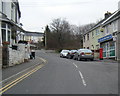
7
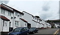
Queen Street houses, Blaina
View from the High Street end looking towards The White Lion Inn. http://www.geograph.org.uk/photo/3576276
Image: © Jaggery
Taken: 26 Jul 2013
0.14 miles
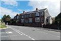
8
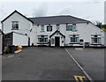
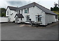
Front view of The White Lion Inn, Blaina
The White Lion is at the NE end of Queen Street, about 175 metres from High Street.
Image: © Jaggery
Taken: 26 Jul 2013
0.14 miles
9
Side view of The White Lion Inn, Blaina
The White Lion is at the NE end of Queen Street, about 175 metres from High Street.
Image: © Jaggery
Taken: 26 Jul 2013
0.14 miles
10
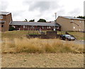
Southlands houses, Blaina
Southlands is an area of housing east of High Street. Former colliery winding wheels http://www.geograph.org.uk/photo/3576317 are on the grass behind the camera.
Image: © Jaggery
Taken: 26 Jul 2013
0.16 miles