IMAGES TAKEN NEAR TO
Abertillery Road, ABERTILLERY, NP13 3EB
Introduction
This page details the photographs taken nearby to Abertillery Road, NP13 3EB by members of the Geograph project.
The Geograph project started in 2005 with the aim of publishing, organising and preserving representative images for every square kilometre of Great Britain, Ireland and the Isle of Man.

There are currently over 7.5m images from over14,400 individuals and you can help contribute to the project by visiting https://www.geograph.org.uk
Image Map
Images are licensed for reuse under creativecommons.org/licenses/by-sa/2.0
Notes
- Clicking on the map will re-center to the selected point.
- The higher the marker number, the further away the image location is from the centre of the postcode.
Image Listing (23 Images Found)
Images are licensed for reuse under creativecommons.org/licenses/by-sa/2.0
Image
Details
Distance
1
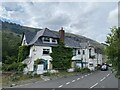
Tilers Arms, Bournville
Roadside public house, now derelict and apparently in danger of collapse.
Image: © Alan Hughes
Taken: 9 Aug 2021
0.01 miles
2
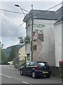
Tilers Arms
Public house, now derelict. Note the old name, painted on the wall behind the render.
Image: © Alan Hughes
Taken: 9 Aug 2021
0.01 miles
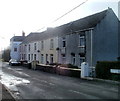
3

Glanyrafon Terrace, Blaina
The houses are set back from Bournville Road at the southern edge of Blaina, near the Bournville boundary. The Tilers Arms pub http://www.geograph.org.uk/photo/2256410 is in the background on the left.
Image: © Jaggery
Taken: 18 Sep 2013
0.03 miles
4
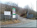
Entrance to Bournville recycling centre, Blaina
The recycling centre, on the east side of Abertillery Road, is managed by Silent Valley Waste Services on behalf of Blaenau Gwent County Borough Council. The site is for recyclable items and household waste.
Image: © Jaggery
Taken: 3 Feb 2011
0.05 miles
5
Tilers Arms, Blaina
Pub at the southern edge of Abertillery Road, viewed from the northern edge of Bournville Road. Among regular features are poker night every Wednesday and live music featuring a vocalist, on the last Friday each month.
Image: © Jaggery
Taken: 3 Feb 2011
0.05 miles
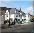
6
Llandovery Villas, Blaina
Llandovery Villas are a row of houses on the west side of Abertillery Road, in the south of Blaina.
At the far end of the row is the Tilers Arms pub. http://www.geograph.org.uk/photo/2256410
Image: © Jaggery
Taken: 3 Feb 2011
0.05 miles
7
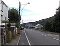
Northern boundary of Bournville
Bournville Road leaves Blaina and enters the small community of Bournville in Blaenau Gwent.
Image: © Jaggery
Taken: 18 Sep 2013
0.08 miles
8
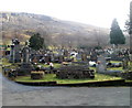
Blaina cemetery
The cemetery is in south Blaina, on the east side of Abertillery Road.
Image: © Jaggery
Taken: 3 Feb 2011
0.10 miles
9
Blaina Cemetery, Gwent
The Chapel and Sexton's house were built approx 1885 and this is also the approximate date that the cemetery opened. Some of the graves were moved here from St Peter's Church when the road widening scheme took place.
Image: © Ann
Taken: 24 Apr 2007
0.10 miles
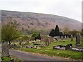
10
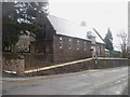
The Sexton's House, Blaina
Viewed across Abertillery Road. The Sexton's House, dating from about 1885, is at the NW corner of Blaina Cemetery. Now converted into one dwelling, the building formerly contained a chapel of rest.
Image: © Jaggery
Taken: 3 Feb 2011
0.10 miles