IMAGES TAKEN NEAR TO
Blaina, ABERTILLERY, NP13 3DL
Introduction
This page details the photographs taken nearby to NP13 3DL by members of the Geograph project.
The Geograph project started in 2005 with the aim of publishing, organising and preserving representative images for every square kilometre of Great Britain, Ireland and the Isle of Man.

There are currently over 7.5m images from over14,400 individuals and you can help contribute to the project by visiting https://www.geograph.org.uk
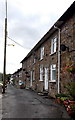
Image Map
Images are licensed for reuse under creativecommons.org/licenses/by-sa/2.0
Notes
- Clicking on the map will re-center to the selected point.
- The higher the marker number, the further away the image location is from the centre of the postcode.
Image Listing (70 Images Found)
Images are licensed for reuse under creativecommons.org/licenses/by-sa/2.0
Image
Details
Distance
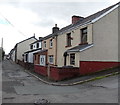
1
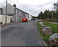
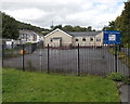
Shop Row, West Side, Blaina
Boulders prevent vehicular misuse of the grassy area.
Image: © Jaggery
Taken: 18 Sep 2013
0.01 miles
2
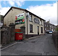
The Yew Tree, Blaina
A banner on the wall of the pub at 8 Railway Terrace shows that this is the home of Blaina United RFC (Rugby Football Club).
Image: © Jaggery
Taken: 18 Sep 2013
0.02 miles
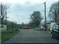
3
West Side, Blaina
Looking towards The Yew Tree http://www.geograph.org.uk/photo/3662024 which is the white building in the background.
Turn left near the red postbox for Victoria Street. http://www.geograph.org.uk/photo/3662026
Image: © Jaggery
Taken: 18 Sep 2013
0.02 miles
5
Blaina Evangelical Church
Located in Shop Row, West Side, Blaina.
Image: © Jaggery
Taken: 18 Sep 2013
0.03 miles
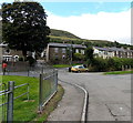
6
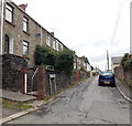
Southern end of Chapel Road, Blaina
The Chapel Road houses are all on one side of the street, facing the backs of houses in Railway Terrace.
Image: © Jaggery
Taken: 18 Sep 2013
0.05 miles
7
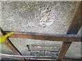
Ordnance Survey Cut Mark
This OS cut mark can be found on the garage east side of the road. It marks a point 284.516m above mean sea level.
Image: © Adrian Dust
Taken: 30 Jun 2023
0.05 miles
8
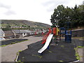
Children's play area, West Side, Blaina
Between Mount Pleasant and Chapel Road.
Image: © Jaggery
Taken: 18 Sep 2013
0.06 miles
9
Mount Pleasant Blaina
Mount Pleasant houses are at the eastern edge of a steep hillside.
Image: © Jaggery
Taken: 18 Sep 2013
0.07 miles
10
Northern end of Railway Terrace, Blaina
The right turn leads to Chapel Road and Inkerman Row.
Image: © Jaggery
Taken: 18 Sep 2013
0.08 miles