IMAGES TAKEN NEAR TO
Upper Trostre, ABERTILLERY, NP13 3DG
Introduction
This page details the photographs taken nearby to Upper Trostre, NP13 3DG by members of the Geograph project.
The Geograph project started in 2005 with the aim of publishing, organising and preserving representative images for every square kilometre of Great Britain, Ireland and the Isle of Man.

There are currently over 7.5m images from over14,400 individuals and you can help contribute to the project by visiting https://www.geograph.org.uk
Image Map
Images are licensed for reuse under creativecommons.org/licenses/by-sa/2.0
Notes
- Clicking on the map will re-center to the selected point.
- The higher the marker number, the further away the image location is from the centre of the postcode.
Image Listing (3 Images Found)
Images are licensed for reuse under creativecommons.org/licenses/by-sa/2.0
Image
Details
Distance
2
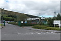
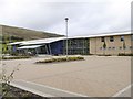
Entrance to Tai Calon Community Housing office in Blaina
Based here in Solis One, Rising Sun Industrial Estate in Blaina, Tai Calon Community Housing was launched on July 26th 2010. Now the largest social landlord in Blaenau Gwent, it was created after tenants of Blaenau Gwent council voted in favour of their homes being transferred to Tai Calon.
Tai Calon is a not for profit organisation. All of its income is invested back into their homes and communities.
Image: © Jaggery
Taken: 18 Sep 2013
0.20 miles
3
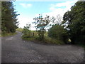
Sharp bend in a track near Coalbrook Vale, Nantyglo
The tracks descends southeastwards on the left and continues northeastwards on the right.
Image: © Jaggery
Taken: 18 Sep 2013
0.24 miles