IMAGES TAKEN NEAR TO
Surgery Road, ABERTILLERY, NP13 3AZ
Introduction
This page details the photographs taken nearby to Surgery Road, NP13 3AZ by members of the Geograph project.
The Geograph project started in 2005 with the aim of publishing, organising and preserving representative images for every square kilometre of Great Britain, Ireland and the Isle of Man.

There are currently over 7.5m images from over14,400 individuals and you can help contribute to the project by visiting https://www.geograph.org.uk
Image Map
Images are licensed for reuse under creativecommons.org/licenses/by-sa/2.0
Notes
- Clicking on the map will re-center to the selected point.
- The higher the marker number, the further away the image location is from the centre of the postcode.
Image Listing (30 Images Found)
Images are licensed for reuse under creativecommons.org/licenses/by-sa/2.0
Image
Details
Distance
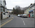
2
Attlee Road, Blaina
Viewed across Surgery Road. A sign showing COEDCAE ESTATE points left along Attlee Road.
Image: © Jaggery
Taken: 26 Jul 2013
0.11 miles
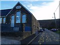
4
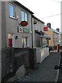
Blaina: Cwmcelyn Post Office
This branch is threatened with closure in the spring of 2008.
Image: © Chris Downer
Taken: 16 Feb 2008
0.14 miles
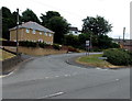
5
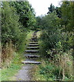
Steps up to a path to Surgery Road, Blaina
Viewed from the road to Cwmcelyn, near Blaina police station. http://www.geograph.org.uk/photo/3574966
Image: © Jaggery
Taken: 18 Sep 2013
0.16 miles
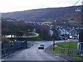
7
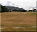
Sports fields in the south of Central Park, Blaina
This is the home ground of Blaina Rugby Football Club, in Central Park on the west side of Surgery Road. The distant rugby posts are about 220 metres from the camera, from which I deduce that there are two pitches here during the rugby season. The other rugby posts have been taken down for the summer, when cricket is played here.
Image: © Jaggery
Taken: 26 Jul 2013
0.17 miles
8
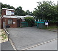
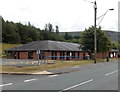
Arosfa Day Centre, Blaina
The day centre is set back from High Street. The access road is adjacent to the fire station. http://www.geograph.org.uk/photo/3574861
Image: © Jaggery
Taken: 26 Jul 2013
0.18 miles
9
Blaina Community Centre
On the left, Blaenau Gwent Psychology Service occupies part of the High Street community centre.
Image: © Jaggery
Taken: 26 Jul 2013
0.18 miles
10
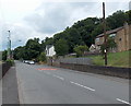
Surgery Road, Blaina
A view NNW from opposite the Attlee Road junction. http://www.geograph.org.uk/photo/3573959 Central Park is on the left.
Image: © Jaggery
Taken: 26 Jul 2013
0.18 miles