IMAGES TAKEN NEAR TO
Hafodarthen Road, ABERTILLERY, NP13 2RY
Introduction
This page details the photographs taken nearby to Hafodarthen Road, NP13 2RY by members of the Geograph project.
The Geograph project started in 2005 with the aim of publishing, organising and preserving representative images for every square kilometre of Great Britain, Ireland and the Isle of Man.

There are currently over 7.5m images from over14,400 individuals and you can help contribute to the project by visiting https://www.geograph.org.uk
Image Map
Images are licensed for reuse under creativecommons.org/licenses/by-sa/2.0
Notes
- Clicking on the map will re-center to the selected point.
- The higher the marker number, the further away the image location is from the centre of the postcode.
Image Listing (168 Images Found)
Images are licensed for reuse under creativecommons.org/licenses/by-sa/2.0
Image
Details
Distance
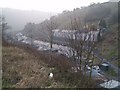
1
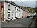
Lower Court Terrace, Llanhilleth
A view NE along Lower Court Terrace from the northern end of Springfield Terrace.
Image: © Jaggery
Taken: 6 Oct 2011
0.04 miles
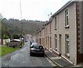
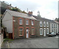
2
Hafodarthen Road, Llanhilleth
The steps on the left (leading up to Victoria Terrace) mark the end of Lower Court Terrace behind the camera, and the start of Hafodarthen Road ahead.
Image: © Jaggery
Taken: 6 Oct 2011
0.04 miles
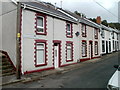
3
Victoria Terrace, Llanhilleth
Viewed from the edge of Hafodarthen Road.
Image: © Jaggery
Taken: 6 Oct 2011
0.04 miles
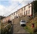
4
Looking SW along Hafodarthen Road, Llanhilleth
There is a two or three metre break in the terraced housing on a bend in Hafodarthen Road.
The gap at the right edge of the view is between number 55 and number 57.
Image: © Jaggery
Taken: 6 Oct 2011
0.05 miles
6
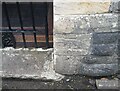
Ordnance Survey Cut Mark
This OS cut mark can be found on the porch of St Mary's Church. It marks a point 151.309m above mean sea level.
Image: © Adrian Dust
Taken: 16 Aug 2021
0.08 miles
7
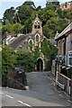
East side of St Mark's Church, Llanhilleth
The Brooklyn Terrace side of the Church in Wales church
in the Diocese of Monmouth. The church dates from 1898.
Image: © Jaggery
Taken: 26 Jul 2023
0.08 miles
8
Brooklyn Terrace, Llanhilleth
Looking north in the direction of Hafodarthen Road. St Mark's church http://www.geograph.org.uk/photo/2637248 is about 40 metres behind the camera.
Image: © Jaggery
Taken: 6 Oct 2011
0.08 miles
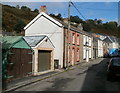
9
Northern end of Brooklyn Terrace, Llanhilleth
Viewed from the NE end of Lower Court Terrace, near where the road becomes Hafodarthen Road.
Image: © Jaggery
Taken: 6 Oct 2011
0.08 miles
10
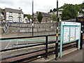
View from Llanhilleth railway station
Image: © Roger Cornfoot
Taken: 24 Aug 2017
0.08 miles