IMAGES TAKEN NEAR TO
Llanhilleth Industrial Estate, ABERTILLERY, NP13 2RX
Introduction
This page details the photographs taken nearby to Llanhilleth Industrial Estate, NP13 2RX by members of the Geograph project.
The Geograph project started in 2005 with the aim of publishing, organising and preserving representative images for every square kilometre of Great Britain, Ireland and the Isle of Man.

There are currently over 7.5m images from over14,400 individuals and you can help contribute to the project by visiting https://www.geograph.org.uk
Image Map
Images are licensed for reuse under creativecommons.org/licenses/by-sa/2.0
Notes
- Clicking on the map will re-center to the selected point.
- The higher the marker number, the further away the image location is from the centre of the postcode.
Image Listing (63 Images Found)
Images are licensed for reuse under creativecommons.org/licenses/by-sa/2.0
Image
Details
Distance
1
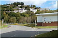
Edge of Llanhilleth Industrial Estate
Viewed along the unnamed access road from the A467. At the northern edge of Llanhilleth Industrial Estate are the premises of SKF (Stainless Kitchen Fabrications).
Houses in the background are on High Street, Maes-y-cnyw Terrace and Hyde Street.
Image: © Jaggery
Taken: 6 Oct 2011
0.06 miles
2
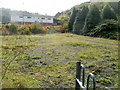
Former play area, Llanhilleth
Play equipment has been removed from a former children's play area opposite Llanhilleth Industrial Estate. A Blaenau Gwent County Borough Council notice on the entrance gate states
PLAY AREA CLOSED sorry for any inconvenience.
Image: © Jaggery
Taken: 6 Oct 2011
0.06 miles
3
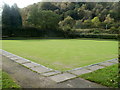
Bowling green, Llanhilleth
Located at the SE edge of a recreation ground on the north side of the A467, the bowling green is used by Llanhilleth & District Bowls Club. Their pavilion is nearby. http://www.geograph.org.uk/photo/2766139
Image: © Jaggery
Taken: 6 Oct 2011
0.06 miles
4
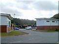
Llanhilleth Industrial Estate
The estate is in the SE corner of Llanhilleth, near a junction with the A467.
Image: © Jaggery
Taken: 6 Oct 2011
0.06 miles
5
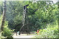
Llanhilleth Colliery Memorial, Granny's Wood
The colliery, opened in 1892, closed in 1969 and the area between the High Street and the railway has reverted largely to woodland.
Image: © M J Roscoe
Taken: 26 Jul 2022
0.06 miles
6
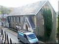
Zion Congregational Church, Llanhilleth, viewed from the north
Viewed from Hillside Terrace across High Street. http://www.geograph.org.uk/photo/2636760 to another view of the church.
Image: © Jaggery
Taken: 6 Oct 2011
0.06 miles
7
Zion Congregational Church, Llanhilleth
The church is the building between the two lamp posts. Located on High Street, it was built in 1877. http://www.geograph.org.uk/photo/2636887 to another view of the church.
Image: © Jaggery
Taken: 6 Oct 2011
0.06 miles
8
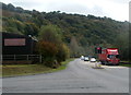
A467 passes edge of Llanhilleth Industrial Estate
The industrial estate is in the SE corner of Llanhilleth. The route of the A467 hereabouts is along the valley of the Ebbw River.
Image: © Jaggery
Taken: 6 Oct 2011
0.08 miles
9
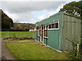
Llanhilleth & District Bowls Club pavilion
The corrugated metal building faces the northern side of the bowling green. http://www.geograph.org.uk/photo/2765949
Image: © Jaggery
Taken: 6 Oct 2011
0.09 miles
10
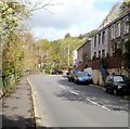
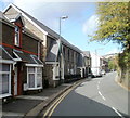
Isolated group of houses at the southern end of High Street, Llanhilleth
The houses on the east side of the B4471, here named High Street, are about 250 metres from the main part of High Street, ahead.
Image: © Jaggery
Taken: 6 Oct 2011
0.09 miles