IMAGES TAKEN NEAR TO
Hillside Terrace, ABERTILLERY, NP13 2RP
Introduction
This page details the photographs taken nearby to Hillside Terrace, NP13 2RP by members of the Geograph project.
The Geograph project started in 2005 with the aim of publishing, organising and preserving representative images for every square kilometre of Great Britain, Ireland and the Isle of Man.

There are currently over 7.5m images from over14,400 individuals and you can help contribute to the project by visiting https://www.geograph.org.uk
Image Map
Images are licensed for reuse under creativecommons.org/licenses/by-sa/2.0
Notes
- Clicking on the map will re-center to the selected point.
- The higher the marker number, the further away the image location is from the centre of the postcode.
Image Listing (54 Images Found)
Images are licensed for reuse under creativecommons.org/licenses/by-sa/2.0
Image
Details
Distance
2
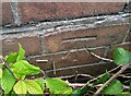
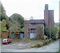
Ordnance Survey Cut Mark
This OS cut mark can be found on the old Pithead Baths. It marks a point 164.741m above mean sea level.
Image: © Adrian Dust
Taken: 16 Aug 2021
0.03 miles
3
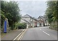
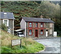
Derelict building on the High Street, Llanhilleth
Image: © Ian S
Taken: 25 May 2014
0.03 miles
4
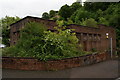
Derelict pit head baths, Llanhilleth
Former pit head baths beside the B4471 at Llanhilleth. The pit head baths served the former Llanhilleth Colliery which closed in 1969. After this the baths remained and were used intermittently by other companies for light industry.
Image: © Philip Halling
Taken: 10 Aug 2012
0.03 miles
5
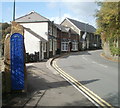
Inconspicuous Llanhilleth boundary sign
Dark blue letters on a dark blue background is not the best combination to grab attention! The view is along High Street looking towards Zion church on the bend.
Image: © Jaggery
Taken: 6 Oct 2011
0.04 miles
6
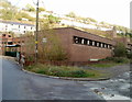
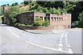
Derelict former pithead baths, Llanhilleth
Located on the east side of Horseshoe Bend, adjacent to High Street (B4471). Formerly part of the now closed Llanhilleth Colliery, the building has been derelict for nearly a decade. It was to be demolished after councillors in February 2008 approved plans to build housing here.
However, this view taken in early October 2011 shows that this has not happened.
Image: © Jaggery
Taken: 6 Oct 2011
0.04 miles
7
NE edge of derelict former pithead baths building, Llanhilleth
The building has been derelict for about 10 years. See http://www.geograph.org.uk/photo/2635804 for another view and brief details.
Image: © Jaggery
Taken: 6 Oct 2011
0.04 miles
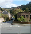
8
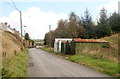
Lock-up garages, Oxford Place, Llanhilleth
A view up Oxford Place from Prospect Place. The Oxford Place houses, all on the left side of the road, begin about 40 metres beyond the garages.
Image: © Jaggery
Taken: 6 Oct 2011
0.04 miles
9
Contrasting houses, Prospect Place, Llanhilleth
The well-maintained appearance of the semi at centre left contrasts with the derelict small semi on the right, with bricked-up windows. Viewed across Oxford Place. At the left edge of the view is Wood Villa.
Image: © Jaggery
Taken: 6 Oct 2011
0.04 miles
10
Prospect Place, Llanhilleth
The six houses in the row on the left are numbered 25-30 Prospect Place. 31 and 32 are on the opposite side of the road. There are no other houses in present-day Prospect Place. On the right is an edge of the derelict former pithead baths. http://www.geograph.org.uk/photo/2635804
Image: © Jaggery
Taken: 6 Oct 2011
0.04 miles