IMAGES TAKEN NEAR TO
Blaencuffin Road, ABERTILLERY, NP13 2RN
Introduction
This page details the photographs taken nearby to Blaencuffin Road, NP13 2RN by members of the Geograph project.
The Geograph project started in 2005 with the aim of publishing, organising and preserving representative images for every square kilometre of Great Britain, Ireland and the Isle of Man.

There are currently over 7.5m images from over14,400 individuals and you can help contribute to the project by visiting https://www.geograph.org.uk
Image Map
Images are licensed for reuse under creativecommons.org/licenses/by-sa/2.0
Notes
- Clicking on the map will re-center to the selected point.
- The higher the marker number, the further away the image location is from the centre of the postcode.
Image Listing (162 Images Found)
Images are licensed for reuse under creativecommons.org/licenses/by-sa/2.0
Image
Details
Distance
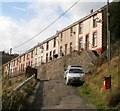
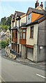
1
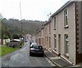
Looking SW along Hafodarthen Road, Llanhilleth
There is a two or three metre break in the terraced housing on a bend in Hafodarthen Road.
The gap at the right edge of the view is between number 55 and number 57.
Image: © Jaggery
Taken: 6 Oct 2011
0.06 miles
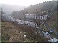
3
Lower Court Terrace, Llanhilleth
A view NE along Lower Court Terrace from the northern end of Springfield Terrace.
Image: © Jaggery
Taken: 6 Oct 2011
0.07 miles
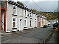
4
Hafodarthen Road, Llanhilleth
The steps on the left (leading up to Victoria Terrace) mark the end of Lower Court Terrace behind the camera, and the start of Hafodarthen Road ahead.
Image: © Jaggery
Taken: 6 Oct 2011
0.07 miles
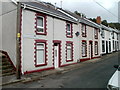
5
Victoria Terrace, Llanhilleth
Viewed from the edge of Hafodarthen Road.
Image: © Jaggery
Taken: 6 Oct 2011
0.07 miles
6
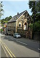
Former Wesleyan Church, High Street, Llanhilleth
Viewed in July 2023. The former church has been converted to flats.
Image: © Jaggery
Taken: 26 Jul 2023
0.08 miles
7
Former Wesleyan Church, High Street, Llanhilleth
Image: © Ian S
Taken: 25 May 2014
0.08 miles
8
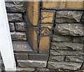
Ordnance Survey Cut Mark
This OS cut mark can be found on the old Wesleyan Chapel on Commercial Road. It marks a point 157.231m above mean sea level.
Image: © Adrian Dust
Taken: 16 Aug 2021
0.08 miles
9
Houses on the north side of High Street, Llanhilleth
The Woodside Terrace junction is in the background.
The notice on the side wall on the right shows
PRIVATE PARKING - OLD BANK ONLY
Image: © Jaggery
Taken: 26 Jul 2023
0.08 miles
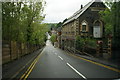
10
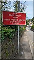
NEW ROAD LAYOUT 100yds, Llanhilleth
English / Welsh sign alongside the B4471 on
the descent towards the centre of Llanhilleth.
Image: © Jaggery
Taken: 26 Jul 2023
0.09 miles