1
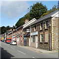
High Street, Llanhilleth
High Street in Llanhilleth is also the route of the B4471.
Image: © Philip Halling
Taken: 10 Aug 2012
0.04 miles
2
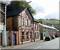
High Street Llanhilleth
Viewed from opposite the Hillside Terrace junction.
Image: © Jaggery
Taken: 6 Oct 2011
0.04 miles
3
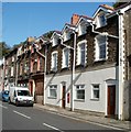
Llanhilleth Police Station
Located on High Street. The inscription in stone at the top of the building is
COUNTY
1898
POLICE
This view was taken in early October 2011. It was reported at a Community Council meeting in July 2011 that "Llanhilleth Police Station is scheduled for closure shortly. Officers will then be stationed in Llanhilleth Institute."
Image: © Jaggery
Taken: 6 Oct 2011
0.04 miles
4
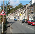
The old post office, Llanhilleth
Located on High Street, next door to the police station (behind the camera). http://www.geograph.org.uk/photo/2636924
The current (early October 2011) post office is inside a Commercial Road Premier store, west of here. http://www.geograph.org.uk/photo/2636998
Image: © Jaggery
Taken: 6 Oct 2011
0.04 miles
5
Hillside terraces, Llanhilleth
Image: © John Lord
Taken: 10 Feb 2009
0.04 miles
6
Llanhilleth RUFC
Image: © Ian S
Taken: 25 May 2014
0.07 miles
7
Llanhilleth Hotel, Llanhilleth
Located at the SE end of Blaencuffin Road, at the junction with High Street.
The Gwent CAMRA (Campaign for Real Ale) website has this:
"Big roadside former Webbs Brewery pub which extended into a former clothing factory next door. Spacious interior includes an upstairs restaurant and ballroom. Bus stop outside."
Image: © Jaggery
Taken: 6 Oct 2011
0.07 miles
8
Higher ground viewed from Llanhilleth Park
Llanhilleth Park occupies one of the few level sites large enough for a sports field in Llanhilleth. Located on the bank of the River Ebbw, it is the home venue for Llanhilleth RFC (Rugby Football Club) and Llanhilleth Town Cricket Club.
This view is looking towards the higher ground to the north and east.
Image: © Jaggery
Taken: 6 Oct 2011
0.07 miles
9
Ordnance Survey Cut Mark
This OS cut mark can be found on the wall NE side of High Street. It marks a point 167.469m above mean sea level.
Image: © Adrian Dust
Taken: 16 Aug 2021
0.07 miles
10
Two warning signs, High Street, Llanhilleth
Adjacent signs warn of a 1 in 7 (14%) descent ahead, and that speed cameras are in operation.
Image: © Jaggery
Taken: 6 Oct 2011
0.07 miles


