IMAGES TAKEN NEAR TO
Windsor Road, ABERTILLERY, NP13 2QE
Introduction
This page details the photographs taken nearby to Windsor Road, NP13 2QE by members of the Geograph project.
The Geograph project started in 2005 with the aim of publishing, organising and preserving representative images for every square kilometre of Great Britain, Ireland and the Isle of Man.

There are currently over 7.5m images from over14,400 individuals and you can help contribute to the project by visiting https://www.geograph.org.uk
Image Map
Images are licensed for reuse under creativecommons.org/licenses/by-sa/2.0
Notes
- Clicking on the map will re-center to the selected point.
- The higher the marker number, the further away the image location is from the centre of the postcode.
Image Listing (37 Images Found)
Images are licensed for reuse under creativecommons.org/licenses/by-sa/2.0
Image
Details
Distance
1
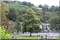
Six Bells Park, Windsor Road
Playground busy in the school holidays.
Image: © M J Roscoe
Taken: 20 Aug 2019
0.06 miles
2
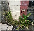
Ordnance Survey Cut Mark
This OS cut mark can be found on the dividing wall between No10 & No11 Marlborough Road. It marks a point 220.221m above mean sea level.
Image: © Adrian Dust
Taken: 16 Aug 2021
0.09 miles
3
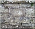
Ordnance Survey Cut Mark
This OS cut mark can be found on the wall of No12 Coronation Road. It marks a point 229.551m above mean sea level.
Image: © Adrian Dust
Taken: 16 Aug 2021
0.10 miles
4
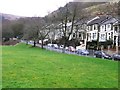
Six Bells recreation ground
One of the few flat areas in this village. Cwm Nant-y-groes can be seen to the left. The square goes halfway up this valley.
Image: © Graham Horn
Taken: 3 Feb 2008
0.11 miles
5
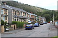
Llwynon Road, Six Bells
Semi-detached and terraced housing typical of the locality.
Image: © M J Roscoe
Taken: 20 Aug 2019
0.11 miles
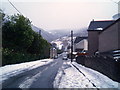
7
Eastville Road, Six Bells
Eastville Road heads NE away from the southern end of Alexandra Road.
Image: © Jaggery
Taken: 16 Feb 2011
0.11 miles
8
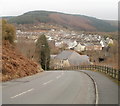
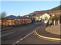
Six Bells village viewed from Six Bells Road
The view NE along Six Bells Road towards the central area of the village of Six Bells and the hills beyond. The building nearest the camera is Bethany Baptist Church. http://www.geograph.org.uk/photo/2274176
Image: © Jaggery
Taken: 16 Feb 2011
0.11 miles
10
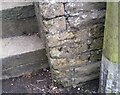
Ordnance Survey Cut Mark
This OS cut mark can be found on the wall of No50 Windsor Road. It marks a point 235.385m above mean sea level.
Image: © Adrian Dust
Taken: 16 Aug 2021
0.12 miles