IMAGES TAKEN NEAR TO
Richmond Road, ABERTILLERY, NP13 2PQ
Introduction
This page details the photographs taken nearby to Richmond Road, NP13 2PQ by members of the Geograph project.
The Geograph project started in 2005 with the aim of publishing, organising and preserving representative images for every square kilometre of Great Britain, Ireland and the Isle of Man.

There are currently over 7.5m images from over14,400 individuals and you can help contribute to the project by visiting https://www.geograph.org.uk
Image Map
Images are licensed for reuse under creativecommons.org/licenses/by-sa/2.0
Notes
- Clicking on the map will re-center to the selected point.
- The higher the marker number, the further away the image location is from the centre of the postcode.
Image Listing (94 Images Found)
Images are licensed for reuse under creativecommons.org/licenses/by-sa/2.0
Image
Details
Distance
1
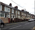
Richmond Road houses, Abertillery
Viewed from Cwm Cottage Road.
Image: © Jaggery
Taken: 5 Mar 2014
0.02 miles
2
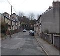
Earl Street, Abertillery
Viewed from the Cwm Cottage Road end.
Image: © Jaggery
Taken: 5 Mar 2014
0.02 miles
3
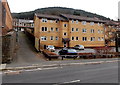
Cwrt Alexandra, Abertillery
Flats on the east side of Alexandra Road.
Image: © Jaggery
Taken: 5 Mar 2014
0.03 miles
4
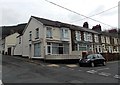
Corner of Cwm Cottage Road and Richmond Road, Abertillery
The car is parked in Richmond Road.
Image: © Jaggery
Taken: 5 Mar 2014
0.05 miles
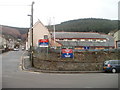
5
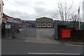
Army Reserve Centre, Abertillery
Viewed across Cwm Cottage Road near the corner of Alexandra Road.
The open gate is a few metres from a notice on the left requesting
PLEASE CLOSE GATE ON ENTERING.
Image: © Jaggery
Taken: 5 Mar 2014
0.05 miles
6
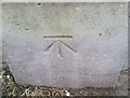
Ordnance Survey Cut Mark
This OS cut mark can be found on the old Drill Hall, Cwmcottage Road. It marks a point 231.291m above mean sea level.
Image: © Adrian Dust
Taken: 20 Jan 2018
0.06 miles
8
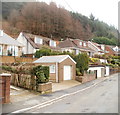
Cwm Farm Road, Penrhiwgarreg, Abertillery
Viewed from the corner of Cwm Cottage Road.
Image: © Jaggery
Taken: 16 Feb 2011
0.06 miles
9
TA Centre, Abertillery
The TA (Territorial Army) centre is on the corner of Alexandra Road and Cwm Cottage Road.
The name signs are (from left to right) :
HEADQUARTERS 211 (SOUTH WALES) BATTERY ROYAL ARTILLERY (VOLUNTEERS)
D TROOP 211 (SOUTH WALES) BATTERY ROYAL ARTILLERY (VOLUNTEERS)
GWENT ARMY CADET FORCE
Image: © Jaggery
Taken: 16 Feb 2011
0.07 miles
10
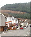
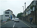
Cwm Cottage Road, Abertillery
Houses on the south side of Cwm Cottage Road, viewed from Cwm Farm Road.
On the distant hillside, a narrow brown band of deciduous trees, bare in late winter, stands out from the green of the surrounding conifers.
Image: © Jaggery
Taken: 16 Feb 2011
0.07 miles