IMAGES TAKEN NEAR TO
Alexandra Road, ABERTILLERY, NP13 2LH
Introduction
This page details the photographs taken nearby to Alexandra Road, NP13 2LH by members of the Geograph project.
The Geograph project started in 2005 with the aim of publishing, organising and preserving representative images for every square kilometre of Great Britain, Ireland and the Isle of Man.

There are currently over 7.5m images from over14,400 individuals and you can help contribute to the project by visiting https://www.geograph.org.uk
Image Map
Images are licensed for reuse under creativecommons.org/licenses/by-sa/2.0
Notes
- Clicking on the map will re-center to the selected point.
- The higher the marker number, the further away the image location is from the centre of the postcode.
Image Listing (79 Images Found)
Images are licensed for reuse under creativecommons.org/licenses/by-sa/2.0
Image
Details
Distance
1
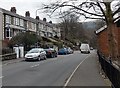
Towards Six Bells from Abertillery
Looking SSE along Alexandra Road towards the village of Six Bells.
Image: © Jaggery
Taken: 5 Mar 2014
0.04 miles
3

Southern boundary of Abertillery
Two inconspicuous purple name signs, one vertical, one horizontal, mark the southern boundary of Abertillery. Located on Alexandra Road, on the corner of Vivian Street. A similar sign http://www.geograph.org.uk/photo/2292987 a few metres away marks the northern boundary of Six Bells.
Image: © Jaggery
Taken: 16 Feb 2011
0.05 miles
4

Northern boundary of Six Bells
A narrow vertical purple sign near the left edge of the view marks the northern boundary of the village of Six Bells. Viewed from Vivian Street, Abertillery, looking towards Alexandra Road.
Similar signs nearby http://www.geograph.org.uk/photo/2292991 mark the southern boundary of Abertillery.
Image: © Jaggery
Taken: 16 Feb 2011
0.05 miles
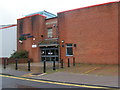
5

Abertillery Bowls Centre
Located in the former Abertillery Sports Centre, Abertillery Indoor Bowls Centre is located at the SE end of Vivian Street. Note that the activity here is bowls, not 10-pin bowling.
Image: © Jaggery
Taken: 16 Feb 2011
0.05 miles
6
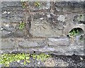
Ordnance Survey Cut Mark
This OS cut mark can be found on the wall of the school on Bryn Gwyn Road. It marks a point 243.032m above mean sea level.
Image: © Adrian Dust
Taken: 16 Aug 2021
0.06 miles
8

Disused public convenience, Alexandra Road, Abertillery
Located opposite Cwrt Alexandra. The gates are padlocked (on a weekday, early afternoon), weeds are growing on the roof and there is rising damp in the structure.
Image: © Jaggery
Taken: 16 Feb 2011
0.09 miles
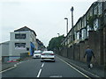
9

Vivian Street, Abertillery
Near the southern edge of Abertillery, Vivian Street descends away from Alexandra Road.
Image: © Jaggery
Taken: 16 Feb 2011
0.09 miles
10
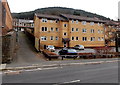
Cwrt Alexandra, Abertillery
Flats on the east side of Alexandra Road.
Image: © Jaggery
Taken: 5 Mar 2014
0.09 miles