IMAGES TAKEN NEAR TO
Railway Street, ABERTILLERY, NP13 2JB
Introduction
This page details the photographs taken nearby to Railway Street, NP13 2JB by members of the Geograph project.
The Geograph project started in 2005 with the aim of publishing, organising and preserving representative images for every square kilometre of Great Britain, Ireland and the Isle of Man.

There are currently over 7.5m images from over14,400 individuals and you can help contribute to the project by visiting https://www.geograph.org.uk
Image Map
Images are licensed for reuse under creativecommons.org/licenses/by-sa/2.0
Notes
- Clicking on the map will re-center to the selected point.
- The higher the marker number, the further away the image location is from the centre of the postcode.
Image Listing (189 Images Found)
Images are licensed for reuse under creativecommons.org/licenses/by-sa/2.0
Image
Details
Distance
1
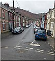
West along Railway Street, Llanhilleth
Railway Street leads to Partridge Road.
Image: © Jaggery
Taken: 25 Jan 2023
0.01 miles
2

Two Celtic Horizons vans, Llanhilleth
Parked in Railway Street in January 2023.
Image: © Jaggery
Taken: 25 Jan 2023
0.01 miles
3
Frosty roofs, Railway Street, Llanhilleth
Overnight hoar frost remains on north-facing roofs at 11:55am on December 8th 2022.
Image: © Jaggery
Taken: 8 Dec 2022
0.01 miles
4
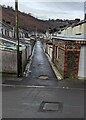
West along a back lane, Llanhilleth
Between the backs of houses in Meadow Street (on the left) and Railway Street.
Image: © Jaggery
Taken: 25 Jan 2023
0.02 miles
5
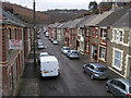
Railway Street
From Meadow Street looking down Railway Street Llanhilleth
Image: © Shaun Ferguson
Taken: 3 Mar 2012
0.02 miles
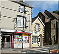
6
Vacant premises formerly Llanhilleth Post Office
Number 7 Commercial Road was formerly Llanhilleth Post Office. Remnants of its previous use include the wall-mounted postbox and the dark green horizontal band above the window. There is a white patch on the left side of the band where once was a yellow-on-red post office logo. There is now a Post Office counter inside the adjacent Premier store http://www.geograph.org.uk/photo/2636998.
An earlier post office was to the east, on High Street. http://www.geograph.org.uk/photo/2636980
Image: © Jaggery
Taken: 6 Oct 2011
0.02 miles
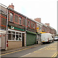
7
Llanhilleth Convenience Store
In premises formerly occupied by The Old Bakery, the Commercial Road convenience store is next door to Phil Tom & Sons, monumental masons. St Mark's Church is on the right. http://www.geograph.org.uk/photo/2765995
Image: © Jaggery
Taken: 6 Oct 2011
0.02 miles
8
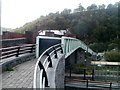
Railway footbridge, Llanhilleth
The footbridge crosses over Llanhilleth railway station on the Ebbw Valley line.
It its alongside the older road bridge.
Image: © Jaggery
Taken: 6 Oct 2011
0.02 miles
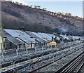
9
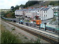
Western end of Llanhilleth railway station
View from a footbridge. http://www.geograph.org.uk/photo/2766049
Llanhilleth railway station was opened on April 27th 2008, as part of the Ebbw Valley route from Cardiff to Ebbw Vale Parkway. The original Llanhilleth railway station, located a little west of here, was opened by the GWR (Great Western Railway) in October 1901. It was closed in April 1962 and later demolished.
Image: © Jaggery
Taken: 6 Oct 2011
0.02 miles
10
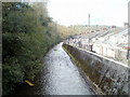
River Ebbw upstream from a footbridge, Llanhilleth
The Ebbw flows towards this footbridge http://www.geograph.org.uk/photo/2825161 past the sloping flood defence wall alongside houses in Meadow Street.
Image: © Jaggery
Taken: 6 Oct 2011
0.02 miles